After several months of dry weather in western North Carolina, April saw plenty of precipitation across that region along with above-normal temperatures across the state.

Temperatures Trend Above Normal
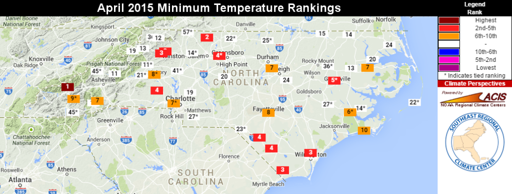
Our warm finish to March carried over into April, as the statewide average temperature of 59.31°F ranked as the 34th-warmest April since 1895. However, our average high temperatures in the low 70s were near-normal for April. So what caused the above-normal mean temperatures?
The culprit may be nighttime cloud cover, which kept our low temperatures on the warm side throughout the month. Average low temperatures ranked among the top ten warmest on record for April at many locations. That includes the seventh-warmest April based on average minimum temperatures in Raleigh and Charlotte, the fifth-warmest in Greenville, and the fourth-warmest in Greensboro.
Most of the state hasn’t seen below-freezing temperatures since a minor freeze event on April 5. And barring a record-breaking May freeze like we had in 1963, it’s likely that most of the state outside of the higher elevations in the mountains has seen its last spring freeze for 2015.
Regular Rainfall Blots Recent Dryness
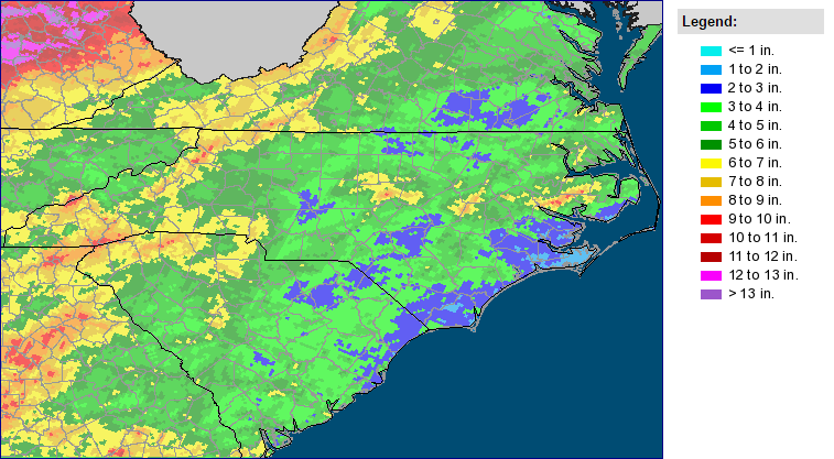
Since last fall, our monthly precipitation summaries have probably sounded like a broken record: wet in the east, dry in the west. We finally reversed that trend in April, as needed rains soaked the western half of the state as well as a corridor from the Triangle across the central coast. The April average precipitation of 4.48 inches ranks as the 28th-wettest April on record.
Parts of the state, including the Triad, had been classified under Abnormally Dry conditions by the US Drought Monitor since last summer. But April’s rains — including 6.14 inches in Charlotte, 7.95 inches in Jefferson, and an impressive 11.19 inches at Highlands in Macon County — helped replenish soils and streams across the region.
The US Drought Monitor has removed all Abnormally Dry conditions from the state, effectively giving us a clean slate as we head into the summer.
What’s behind the change in our rainfall pattern? It may be partly explained the building El Niño in the Pacific. Sea surface temperatures in the eastern equatorial Pacific warmed to more than a degree above normal during April, which means El Niño conditions are in place.
Although El Niño’s spring and summertime influences on North Carolina are often much weaker than in winter, it can still have some impact. Many of our April rain events were due to an active southern branch of the jet stream, which is one common effect of El Niño events.
That doesn’t mean we should expect more of the same for May, though. In its May precipitation outlook, NOAA’s Climate Prediction Center puts North Carolina in an equal chance of seeing above- or below-normal precipitation. Their latest discussion notes that “the typical wintertime El Nino impacts [were] introduced into the outlooks… albeit at low probabilities.”
Fire, Flooding, and Hail Among April’s Hazards
An active weather pattern in April also meant several hazards. Early in the month, a wildfire started just east of Asheville near Black Mountain and Montreat, apparently the result of debris burning that was never properly extinguished. The so-called Weed Lane fire burned 740 acres between March 31 and April 8 before crews led by the NC Forest Service (and aided by the rain) got it under control.
Heavy rains on April 19 near Charlotte and Boone caused localized flooding. Accumulations of more than two inches in eight hours or less caused creeks to reach their flood stage, and several roads were closed due to high water.
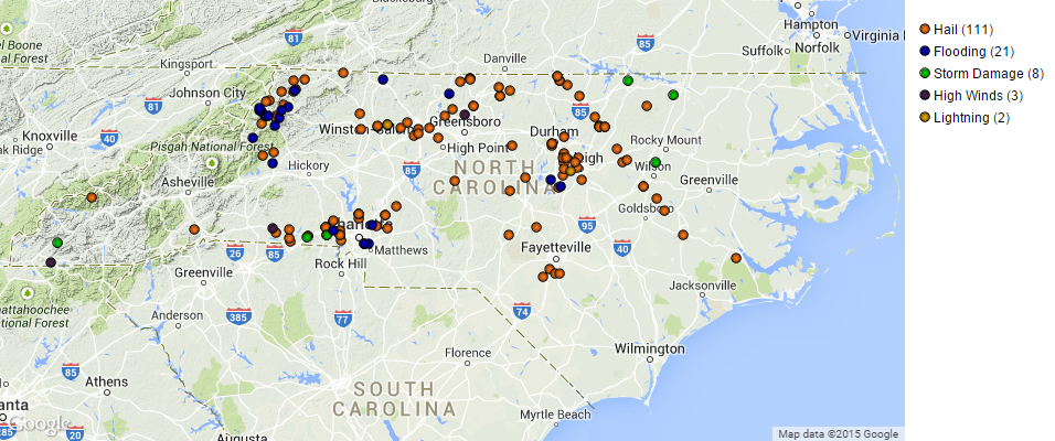
Several thunderstorm events during the month brought hail to some areas. On April 8 and 9, a particularly strong storm dropped up to two-inch hail as it moved from near Roxboro southeastward through Kinston and New Bern.
More storms on April 20 brought hail up to 1.25 inches in diameter near Charlotte and Winston-Salem. And in Raleigh, the month rounded out on April 30 with a brief but intense period of pea-sized hail, which covered the ground in some areas.
Despite the storms last month, no tornadoes were reported across the state. A tornado-free April isn’t unusual — 29 times since 1950, or 44% of all years, we’ve had no confirmed April tornadoes in North Carolina — but April is also when we’ve seen some of the more widespread tornado outbreaks, including the record event from 2011.