The first statewide wintry event of the season brought a mixed bag of precipitation types and left an icy glaze across parts of North Carolina.
The mix of precipitation was no surprise with this system; it brought the same sort of conditions to our west as it approached the Appalachians: Alabama and Mississippi received mostly rain, much of Tennessee saw a mix of sleet and freezing rain, and Kentucky came away with several inches of snow.
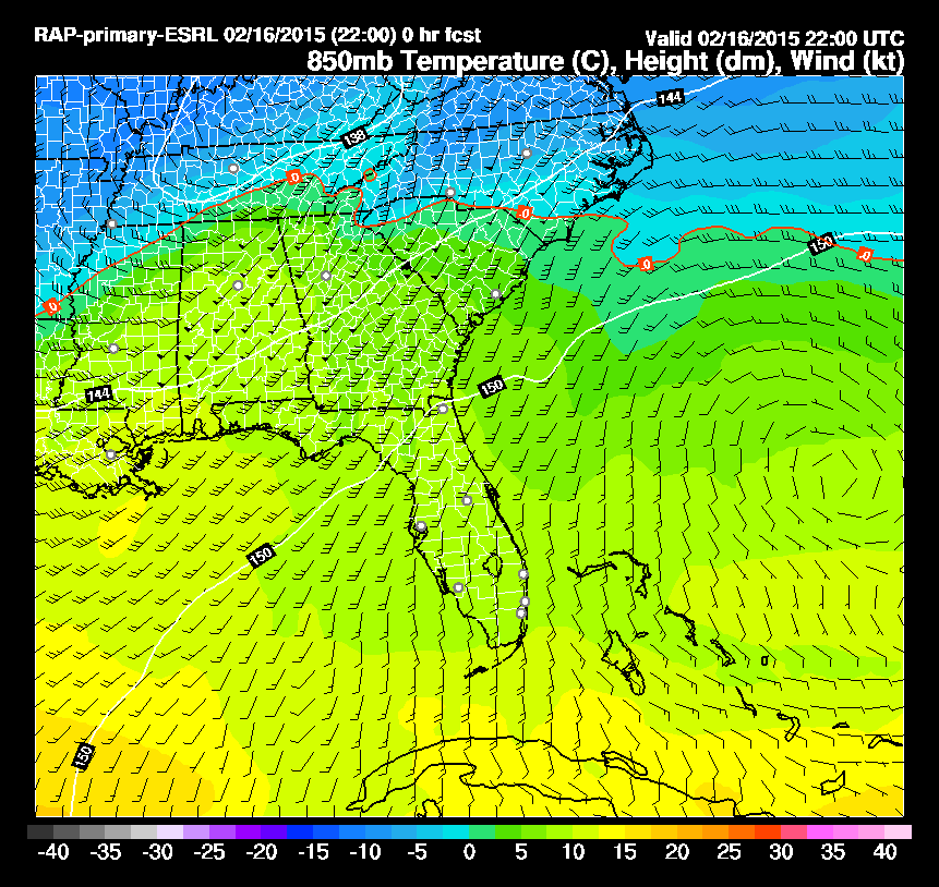
While that low pressure system tracked to our south, a high pressure system over North Carolina meant cold, dry air was in place near the ground. As precipitation fell into that dry air, evaporative cooling helped lock in the near-surface cold wedge across all but the far southern and eastern parts of the state. That ensured our precipitation would remain in a frozen form. But the question was, which type would it be?
When precipitation began falling in western and central North Carolina on Monday afternoon, the entire atmosphere was below freezing, so everything fell as snow. However, a feed of warm air from the south about 5,000 feet above the surface meant that layer of the atmosphere would get above freezing for most of the state.
Check out the northward progression of the red 0°C (freezing) line in the animation below to see how this layer rose above freezing during the event.
The lower levels of the atmosphere stayed below freezing for the northern Mountains, foothills, and Virginia border counties of the Piedmont, so they saw mostly snow during the event. The National Weather Service in Blacksburg reported as much as six inches of snow at Blowing Rock and Laurel Springs in the northwest corner of the state.
Just south of that, from the southern Mountains including Asheville through the Triad, precipitation began as snow but switched to sleet overnight as this narrow layer got just above freezing.
We can also see this in the weather balloon sounding data from Greensboro, which gives a look at the temperature and dew point profiles throughout the atmosphere. At 7 pm, or 0 GMT, on Monday night, the air column above Greensboro was fully below freezing, with a near-freezing layer around 800 mb — again, about 5,000 feet up.
By 1 am, or 6 GMT, this thin layer became a “warm nose” a few degrees above freezing, which allowed falling snowflakes to briefly melt, then re-freeze into ice pellets or sleet in the colder layer below.
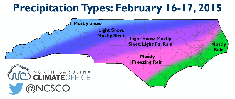
Points farther south and east weren’t quite as lucky. This warm nose was even warmer and deeper, so some falling snowflakes melted into raindrops and froze at the surface. As the map below shows, the corridor from Charlotte to Raleigh to Greenville received a brief period of snow, then mostly sleet with some light freezing rain mixed in.
South of there, from Fayetteville to Goldsboro to New Bern, the event was almost all freezing rain. The weight of more than a half-inch of ice caused trees and power lines to fall, resulting in numerous power outages — more than 56,000 customers were without power as of 10 a.m. on Tuesday.
While these areas were hit hard by the ice, it fortunately wasn’t a more widespread ice storm. Many computer models predicted a more prominent and deeper warm nose across central North Carolina and up to an inch of total precipitation falling. Both of those were overdone in the model forecasts, so the end result was an overall lighter precipitation event with more sleet, less freezing rain, and less statewide impact.