NC Extremes: The Coldest Day Redefined Records

This is the first post in a year-long series documenting some of North Carolina’s weather extremes. Today’s post looks at the event that brought the coldest air on record to most of the state.
They say that records are made to be broken. But on January 21, 1985, the temperatures were so frigid that this event is now known by the superlative, “the Coldest Day”. On that morning, North Carolina temporarily became an ice box, rewriting our low temperature records in the process.
Setting the Stage
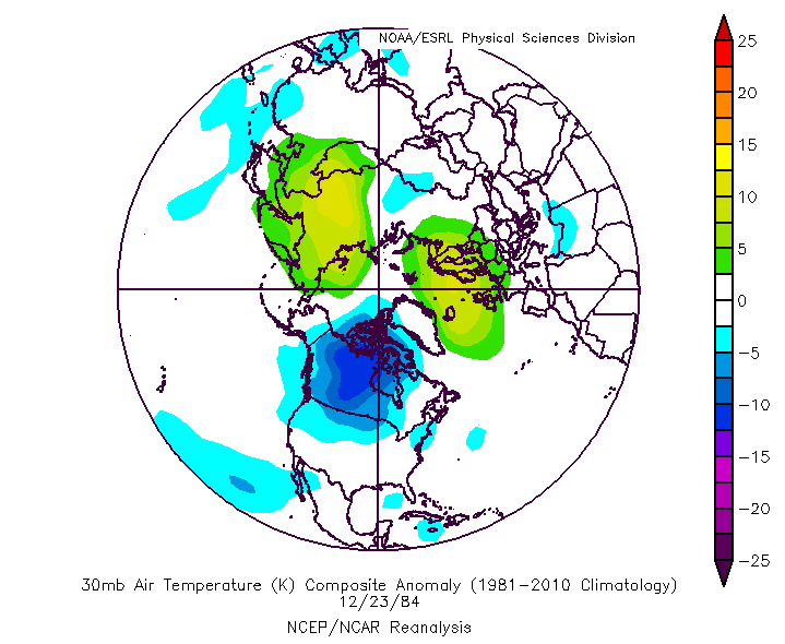
The setup for this record cold weather began, perhaps surprisingly, with warming: namely, a sudden stratospheric warming (SSW) event in the upper atmosphere. Although the interplay between the troposphere — the lowest layer of our atmosphere — and the stratosphere — which begins six to ten miles above the surface — is fairly complex, the basics can be explained in a few steps:
- If circulations in the upper atmosphere weaken, the barrier breaks down between colder air around the north pole (which receives little to no sunlight in the winter) and warmer air to the south. This can cause rapid upper-level temperature increases — sudden stratospheric warming.
- Weaker circulations associated with SSW mean upper-level winds also weaken or even reverse from westerly to easterly. These winds can migrate down into the upper troposphere and weaken the polar jet stream.
- A weaker polar jet stream also means a weaker polar vortex — the semi-permanent low pressure system usually centered over the north pole. When the polar vortex is strong, it remains right over the pole. However, when it weakens, it tends to meander a bit more.
- During particularly strong SSW events, which happen every few years, the polar vortex can even split into two or more small vortices and dive to the south, bringing Arctic air along with them. This happened during a more recent cold air outbreak in January 2014.
The Timeline
A SSW event occurred at the turn of the new year in 1985. Stratospheric temperatures increased by 25°C (45°F) or more in about a week, as the animation above shows. Starting around January 13th, an upper-level low associated with a piece of the polar vortex began diving south over Canada, eventually dropping as far south as Michigan.
At the surface, a low pressure system and a cold front moved across the midwest and eastern US. Behind the front was a cold, dry air mass that warmed very little as it moved south thanks to a blanket of snow covering most of the country.
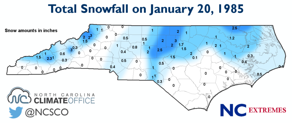
The front moved through North Carolina on the morning of January 20th, bringing light snow across parts of the state. Although the accumulations weren’t substantial — most places received two inches or less — that snow on the ground radiated heat back out to space, keeping surface temperatures cold.
By 6 pm on the 20th, most of the state had already fallen into the single digits. That evening, the skies cleared and dew points dropped to near record lows: -30°F in Charlotte, -29°F in Greensboro, and -28°F in Raleigh. That combination of clear skies and cold, dry air set the stage for the historic low temperatures the next morning.
The Cold, All Told
Across the state, more than 80 weather stations broke or tied all-time low temperature records that still stand today.
The Mountains faced the worst of the cold. Mount Mitchell hit -34°F, shattering the statewide low temperature record. The previous record, -26°F, had been held by Banner Elk and Grandfather Mountain. Both of those sites broke that record on the Coldest Day as well: Grandfather Mountain hit -32°F and Banner Elk hit -31°F.
Elsewhere, Asheville bottomed out at -16°F, breaking its old record of -7°F. Charlotte (-5°F), Greensboro (-8°F), and Raleigh (-9°F) each broke their old records as well. In the central Piedmont, Siler City hit -11°F thanks in part to the 2.5 inches of snow on the ground.
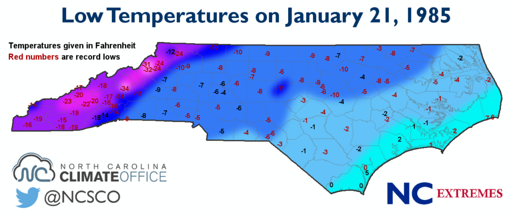
Along the coast, temperatures hit the single digits, with Hatteras (6°F), Morehead City (1°F), and Wilmington (0°F) each setting new records. Hatteras hasn’t seen single-digit temperatures since this event, and the cold weather resulted in ice floes in the Pamlico Sound.
At the time, it was estimated that North Carolina suffered $11 million in agricultural losses, mainly from peach crops that couldn’t weather the extreme cold. In addition, 14 people died across the state due to hypothermia and exposure.
Event Perspectives
Although the event barely lasted two days, it left a lasting impact on our memories of that winter. Average temperatures for the 1984-85 winter in North Carolina were a half degree above normal, ranking as the 52nd-warmest (or 68th-coolest) winter on record, and the state saw below-normal snowfall with only one or two minor events. Yet the winter of 1985 evokes chills because of “the Coldest Day”.
Perhaps that’s rightfully so. In the 30 years since then, most of those records haven’t been broken and have rarely been threatened. And given the incredible pattern and perfect ingredients that converged at the right time, these chilly extremes are unlikely to fall any time soon.
- Categories:


