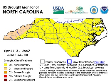
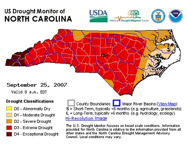
This is the first in a multi-part series looking at drought. Before we cover some the drought tools we’ve developed, we thought it might be best to provide some basics on drought monitoring and prediction.
Drought is a part of North Carolina’s climate, defined as a deficit in normal precipitation for a region over a period of time sufficient to cause impacts. At any given time, some part of the US is experiencing a drought, and this can have sufficient environmental, economic, and even social impacts far beyond the geographical or temporal limits of the drought itself. North Carolina is no exception, and this is why it’s so important to monitor drought conditions frequently, even if we’re not currently within a drought.
Spring is often the time of year when we assess our current drought status and think about drought risks for the summer. This post will cover why this is such an important time for drought development, along with whether and how we can monitor and predict drought emergence across the state.
Why spring?

North Carolina generally receives fairly uniform rainfall each season, as compared to, for example, south Florida, which has distinct wet and dry seasons. Water input from precipitation is relatively consistent season to season, but water loss, through evaporation and plant transpiration, varies throughout the year.
Low temperatures and dormant vegetation means that most of the water that falls in the cool months generally goes to recharge our groundwater, rivers, and reservoirs. In contrast, during the summer we lose more moisture to the atmosphere, through evaporation and plant transpiration, than we receive from rain.
Mid-spring is generally the time when we start losing more water than we gain from precipitation, and the time when our water resources are at their highest levels of storage in lakes and groundwater. Consequently, spring is a fitting time to assess whether or not we have enough water to make it through the summer. If we have a very dry winter, as sometimes happens, especially during a La Niña, we might not have reached full storage of water by mid-spring. Less than full storage doesn’t guarantee water problems in the summer, but it certainly increases the chances.

How do we monitor for drought conditions?
We define drought severity largely based on impacts to vegetation, water resources, and fire risk. However, we usually don’t want to wait until we see major impacts in these areas before raising alert levels. It’s also very difficult to collect some of this data – for example it can be challenging to determine exactly when and where a tree or crop might experience drought stress.
So, instead, we rely heavily on objective monitoring data, especially sensors that report temperature, precipitation, and water levels in streams, reservoirs, and aquifers. We build indices using these data to convey drought risk in forests, agriculture, and water supplies. But there is no single best drought index, so we generally look at a range of drought indicators. We also rely heavily on input from folks in each county who are looking for signs of drought, especially water managers and agriculture extension agents.
Each week, a subset of technical experts with the NC Drought Management Advisory Council meets to review current conditions and make recommendations to the US Drought Monitor program on how we think drought severity should be depicted for NC.

Can we predict drought?
No. At least not usually. We can often make meaningful seasonal forecasts for the winter season in the southeastern US, so we can sometimes suggest whether or not the odds increase that we might not fully recover our water storage. But most drought impacts are felt in the warm months when we almost never have the ability to make meaningful seasonal forecasts.
It’s this lack of forecast ability that makes drought monitoring so important. Timely, routine, local-scale monitoring ensures that we stay on top of situations as they develop and can aid agencies that provide drought planning and relief.