Signs of Spring Emerge in February, Despite a Snowy Speed Bump

Last month saw mostly warm temperatures plus above-normal precipitation for much of the state. That has put spring-like weather – and impacts – at our doorstep.
Warm Bookends to the Month
Following our cool January, we saw a decisive warm-up in February with above-normal temperatures overall for the month. The National Centers for Environmental Information (NCEI) notes a preliminary statewide average temperature of 45.8°F and our 25th-warmest February out of the past 130 years.
Among local weather stations, the warmest spots were in the west. It was tied for the 10th-warmest February on record in both Hickory and North Wilkesboro, the 10th-warmest outright in Lincolnton, and the 9th-warmest for Boone and Celo.
January’s chill was nowhere to be found once the calendar rolled over, as temperatures hit the 70s in all three regions of the state on February 1. Hot Springs reached a high of 73°F two weeks earlier than average, and almost a month earlier than last year’s first day that warm there.
With warm high pressure to our south on February 4, we even saw some 80-degree readings in areas such as Charlotte, Raleigh, and Smithfield. In the Queen City, it was their second-earliest 80-degree day on record, behind only the February 2 occurrence in 1989.
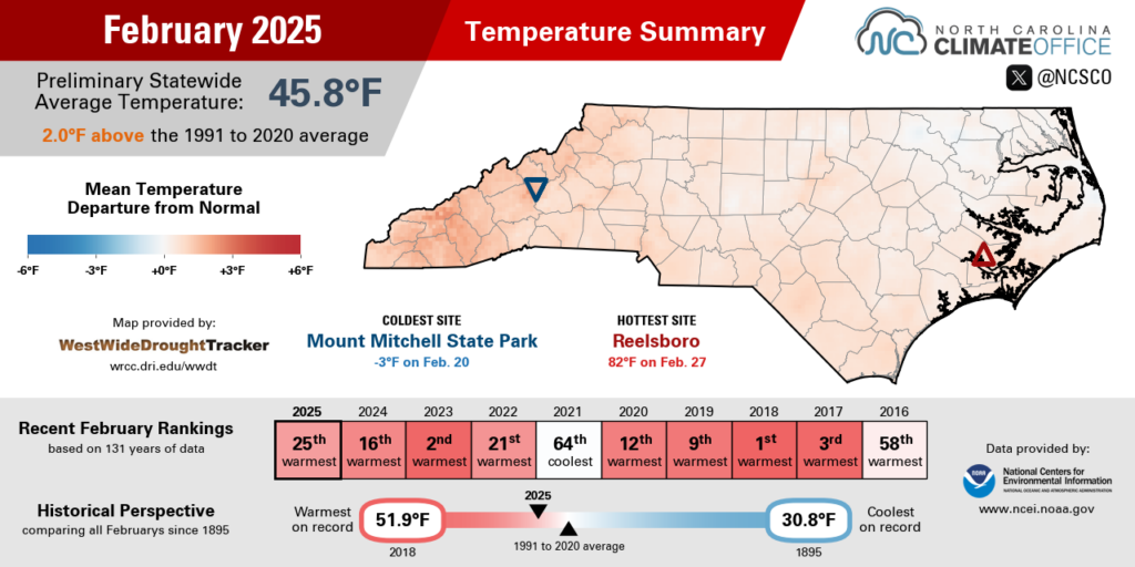
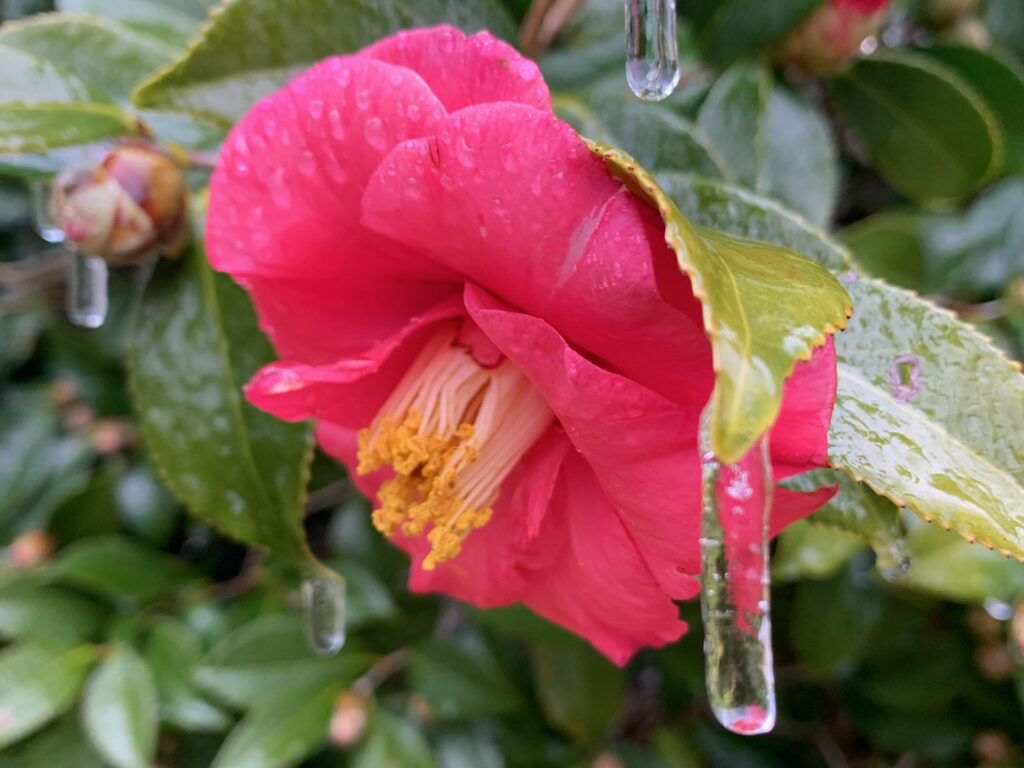
Unseasonable 70s continued through February 10, after which we saw a brief cooldown when a cold front moved through. Another shot of cold air arrived on February 19-20 during the month’s lone widespread wintry event.
With snow on the ground across northeastern North Carolina, temperatures tumbled into the teens, including a low of 16°F on February 21 in Elizabeth City – the coldest February morning there in exactly a decade, since February 21, 2015.
Warm weather returned again for the final days of the month as another high pressure system built in over the Southeast US. Temperatures statewide topped out in the 70s on February 26, 27, and 28, with a few localized 80-degree readings at Sandhills sites such as Hamlet and Laurinburg.
It’s the sort of weather we’ve come to expect this time of year, as each of the past ten Februarys has been warmer than the 20th-century average statewide. And even a bit of snow and ice couldn’t stand in the way of that warmth last month.
Rain and Snow Return
Following a string of four consecutive dry months dating back to last October, February finally saw wetter-than-normal conditions, especially in northern and western areas. Statewide, NCEI reports a preliminary average monthly precipitation of 3.75 inches, which was 0.38 inches wetter than the 30-year average and ranked as our 70th-wettest February — or the 62nd-driest, due to having more wet Februarys than dry ones historically.
Several sites in the Mountains and Foothills were more than two inches above their normal precipitation last month, including Mount Airy, which was 2.11 inches above normal in its 17th-wettest February on record, and Bent Creek just south of Asheville, which was 2.83 inches above normal in its 3rd-wettest February out of the past 24 years.
Those sites benefitted from a series of frontal systems that soaked the western part of the state in the middle of the month. On February 13, the daily totals measured as much as 3.02 inches at Lake Toxaway, with 2.58 inches in Bryson City – the wettest single day there since the passage of Hurricane Helene last September.
In the northern Coastal Plain, Elizabeth City saw a moisture boost from 8 inches of snow, and it finished February 0.43 inches above its normal precipitation. In Roanoke Rapids, its 13th-wettest February on record was the first wetter-than-normal month there since last July.
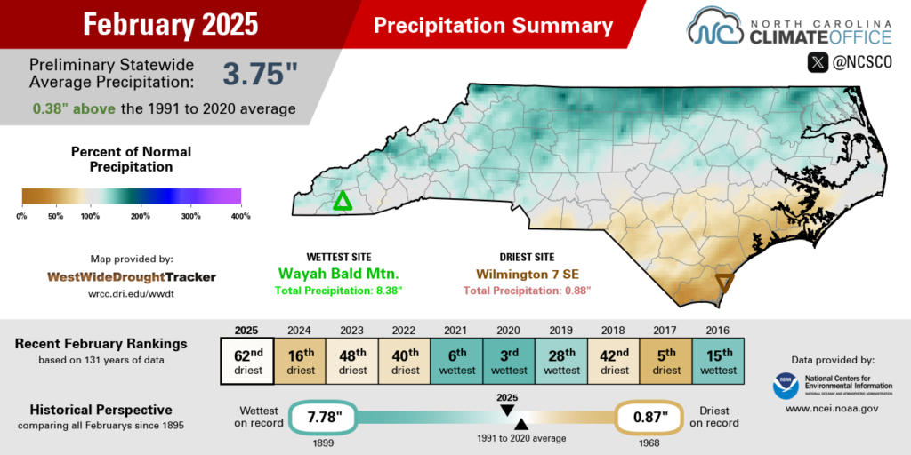
Charlotte and Raleigh both ended the month within a few hundredths of an inch of their normal precipitation, while the monthly totals dropped off to less than two inches south and east of there.
Fayetteville was 1.70 inches below normal in its 21st-driest February on record. Wilmington was 2.22 inches below normal in its 11th-driest February dating back to 1870. And Longwood in western Brunswick County had only 1.14 inches of precipitation all month in its 3rd-driest February out of the past 52 years.
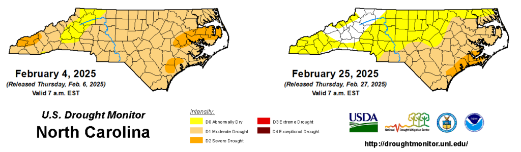
Much of the state saw improvement on the US Drought Monitor last month, with Moderate Drought (D1) peeled back across most of the Mountains and Piedmont. However, the Coastal Plain is still dealing with drought and its impacts, including Severe Drought (D2) along parts of our southern and central coastline.
Key impacts include lingering low streamflows in those areas, groundwater levels that were sluggish to recover this winter and remain below normal, and a deep layer of dryness in soils that has become a harbinger of – and fuel for – wildfires as we head into the spring.
Spring is Springing
This February didn’t feature the same wall-to-wall warmth as last year, and we had more wintry precipitation last month than in any February since 2020. However, we’re still seeing the steady progress of spring, which has taken a few different forms in recent weeks.
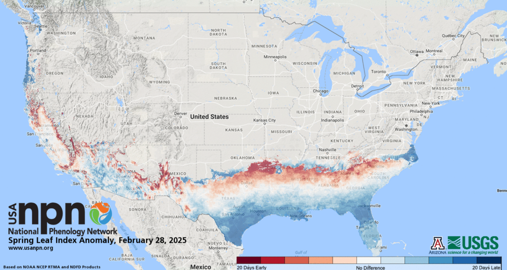
The warmth early in the month was a wake-up call for trees and plants to start budding, and the first leaves emerged in the Charlotte area about five days earlier than normal, according to analysis from the National Phenology Network.
Interestingly, the entire state hasn’t seen that same trend. Parts of the northern Coastal Plain that were covered in snow mid-month saw a delay in their own first leaf emergence, and it occurred one to two weeks later than normal there.
Your nose may have let you know about another sign of spring. Pollen has been proliferating since our late-month warm-up, with the Forsyth County Office of Environmental Assistance and Protection measuring Very High tree pollen levels in the Triad.
Much of that was from cedar trees, which are typically one of our first local species to jump-start the allergy season. For more on cedars, the FCEAP recently profiled its pollen in a blog post written by Dr. Joel Gallagher from Allergy and Asthma Center of NC, who went under the microscope to show how its larger proteins affect our immune systems.
Another unfortunate sign of spring has been an early start to the spring wildfire season. Last month, we noted that firefighters in western North Carolina had spent part of their typically quiet winter months containing two large fires in McDowell County, which in one case prompted local evacuations near Old Fort.
A decent dose of rain in mid-February helped tamp down those fire concerns in some areas, and we briefly saw not-too-wet and not-too-dry conditions that supported beneficial prescribed burning in parts of the state.
But following a cold frontal passage on February 27, a less humid air mass packing some gusty winds moved in, and combined with the ongoing Abnormally Dry and drought conditions affecting much of the state, the fire risk ramped up once again.
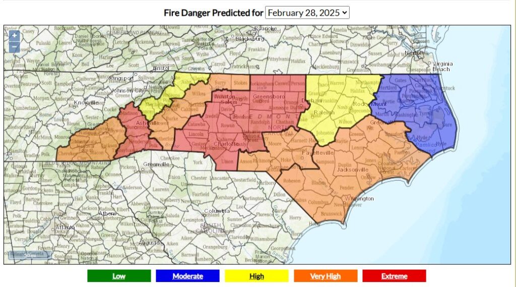
Beginning on Friday, February 28, fire danger hit the Extreme level – the highest of five categories on the Adjective Rating scale – in parts of western North Carolina, with forecasts for Very High to Extreme conditions statewide through the first weekend of March. During that time, a brush fire spread across more than 500 acres in Polk County, with additional fires burning in the Nantahala, Pisgah, Uwharrie, and Croatan national forests.
Fire danger at the Extreme level is a rare event. In all of 2023 and 2024, there were only seven days with Extreme conditions in any of the state’s Fire Danger Rating Areas, which the NC Forest Service uses to communicate these forecasts to the public, often via the Smokey the Bear signs at parks, forests, and other facilities.
With dry conditions lingering and fire season already ramping up, it’s a good reminder not to burn on days with elevated fire danger or when burn bans are in place, and to always practice fire safety when burning backyard debris.
If a wildfire is burning nearby or if you smell smoke in the air, you can check our Air Quality Portal for the latest local forecasts from the NC Division of Air Quality and current conditions from weather stations and air quality monitors across the state.
- Categories:


