
July saw a wet start including Tropical Storm Chantal and month-long warmth, especially overnight. To help communities prepare for hot weather like that, an Extreme Heat Cohort is being offered again this year.
Chantal Leads a Storm-Soaked Month
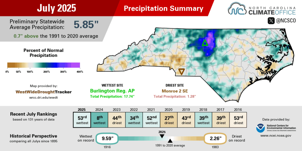
Our first tropical event of the season, plus plenty of other rainy days, made for an overall wet July in North Carolina. The National Centers for Environmental Information (NCEI) notes a preliminary statewide average precipitation of 5.85 inches and our 53rd-wettest July out of the past 131 years.
The biggest rain event of the year so far came on the first weekend of the month, when Tropical Storm Chantal moved through on Sunday, July 6 and dropped heavy rain across the central and eastern Piedmont and Sandhills.
With 8 to 10 inches of rain falling in only 12 hours or so, the flooding was significant, especially in Alamance, Chatham, and Orange counties. The Haw and Eno rivers each hit record crests, and six deaths occurred, including four people whose vehicles were submerged.
National Weather Service offices across the state also confirmed five tornadoes touched down during Chantal, with one near the Wilmington airport and four in the Triangle area, including one at the Raleigh Executive Jetport in Sanford that damaged several hangars and aircraft.
Following Chantal, there was little relief for these storm-affected areas, as daily pop-up showers and thunderstorms targeted the same parts of the Piedmont that were soaked by the tropical storm. On July 9, more than 2 inches fell in Durham County, while Chapel Hill had an additional 3 inches on July 15 with even higher totals around Jordan Lake in Chatham County.
Burlington finished the month with 17.74 inches of rain, easily surpassing the 11.91 inches from September 1999 to become the wettest month on record there, and Chapel Hill had its wettest July on record with 16.41 inches. It was also a record wet month for Yanceyville dating back to 1996, with 17.50 inches in total.
Away from Chantal’s heaviest rain but still in the path of multiple mid-month showers, Greensboro had its 9th-wettest July with 9.19 inches. The Piedmont Triad International Airport reported 34 hours with thunderstorms occurring, which was the most in any month since July 2004.
While most of the state was wetter than normal in July, parts of the southern Piedmont and central coastline missed out on most of the rain. Bayboro was 2.49 inches below normal in its 14th-driest July on record, while Charlotte had only 1.33 inches in its 13th-driest July and Monroe had 1.28 inches in its 7th-driest July dating back to 1896.
Those areas were classified as Abnormally Dry (D0) by the end of the month, reflecting the lack of rain in July and a drop in streamflow levels. Fortunately, our moisture reserves from earlier in the summer have helped avoid more widespread degradation during the recent hot weather, and despite some decreases in soil moisture, crop conditions remain mostly good statewide.

High Heat and Humidity
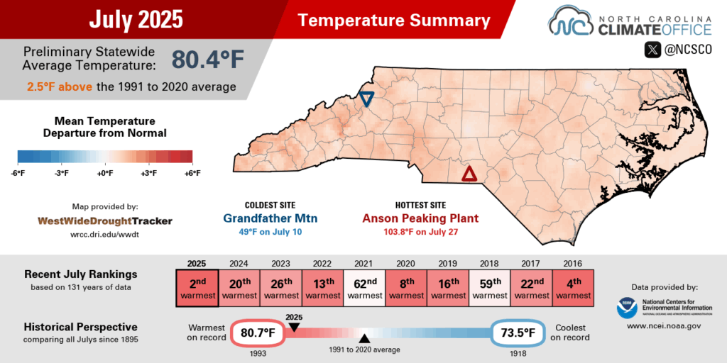
With summer in full swing, it was a hot and humid month that ranks among our warmest Julys on record. NCEI reports a preliminary statewide average temperature of 80.4°F, which was our 2nd-warmest July since 1895.
It finished as the warmest July on record for Raleigh and tied for the warmest in Asheville. It was the 2nd-warmest July for Hickory and Hatteras, tied for the 2nd-warmest in Charlotte, Greenville, and Lumberton, and tied for the 4th-warmest in Greensboro.
That warmth wasn’t just from sunny afternoons. Our overnight temperatures were unrelenting, and based on the average minimum temperature, it was the warmest July on record in North Carolina. Locally, we had the warmest average low temperatures ever recorded for an entire month at sites such as Asheville, Charlotte, Greensboro, Raleigh, and Lumberton.
A big reason for those warm nights was the high humidity. For much of the month, a southerly circulation around the offshore Bermuda high pressure system brought in moisture off the Gulf and the Atlantic. In addition, as residual moisture from our early-month rainfall in soils, vegetation, and surface water sources evaporated, it added even more water vapor to an already muggy air mass.
Raleigh had its highest average dew point – 69.8°F – out of any July since 1946. Among our 39 ECONet stations with at least 10 years of observations, 33 of them had record-high average dew points for the month of July, including in the Mountains at Fletcher, in the Sandhills at Jackson Springs, and in the Coastal Plain at Lewiston.
As in June, the hottest weather came in the final week of the month as a heat dome-like high pressure pattern set up over the Southeast US. The warmest conditions came across the southern Piedmont, where the drier weather and slightly lower dew points made it easier for the mercury to climb.
Charlotte recorded three consecutive 100-degree days for the first time since June 2015, with a peak of 102°F on July 27 – its warmest day since July 1, 2012. Our Lilesville ECONet station topped out at 103.8°F, also its hottest temperature since 2012.
An old saying goes that it’s not the heat but the humidity, but in July, it was both. That combination made for extreme apparent temperatures all across the state. Traditional Heat Index values exceeded 100°F from the Foothills to the Outer Banks on July 26 and 27, including a peak value in Hatteras of 111.4°F — its highest Heat Index since August 1, 1999 — and a maximum value of 117.5°F at our ECONet station on Bald Head Island.
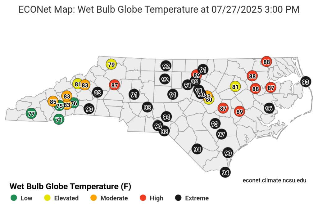
As we recently documented, the Wet Bulb Globe Temperature is a more accurate indicator of heat stress on the human body in direct sunlight, and 11 of our ECONet stations set new record high WBGTs last month, all on July 27. That included peak values of 99.1°F in Wallace and 98.1°F in Aurora, breaking its previous record that was set during our June heat wave.
All but our seven high-elevation stations spent time in the High or Extreme WBGT ranges last month, and five Sandhills or coastal stations — in Lilesville, Wallace, Bald Head Island, Aurora, and Jockey’s Ridge — had more than 10,000 total minutes, or the equivalent of more than a full week, with those High or Extreme heat risk conditions. That’s a sign of just how common and hazardous those hot and humid July days were.
Seeking Communities for a Heat Cohort
As late July showed with dozens of hospital admissions for heat-related illnesses, exposure to extreme heat poses risks to public health and strains household budgets with higher cooling costs. For communities across the state, preparing for these hot periods is imperative so that heat and its impacts don’t catch us by surprise.
To help local leaders plan for heat-related health and safety measures, the State Climate Office is partnering with the State Resilience Office again this year to offer the Planning for Extreme Heat Cohort Program.
Throughout this seven-month virtual program, participants from local municipalities and county governments will learn more about heat-related actions and interdepartmental plans to handle extreme heat in their communities, tying in with current practices and laying the groundwork for future initiatives.
Participants in the cohort gain access to trusted experts in weather and climate, policy, planning, and implementation, including from the NC Department of Health and Human Services, Duke University’s Heat Policy Innovation Hub, the NC State Climate and Sustainability Academy, and the National Weather Service’s Raleigh forecast office.
Collaborating with peer communities offers opportunities for shared learning and developing best practices, as several of last year’s participants highlighted on a recent webinar with takeaways such as neighborhood check-ins and buddy systems for outdoor workers, as the City of Burlington is now using.
During the program, participants develop a draft heat action plan for their communities using the State Resilience Office’s Heat Action Plan Toolkit, which includes a heat action plan template with suggested mitigation strategies, public communication design samples, and more. The State Climate Office supported the design of this tool.
And they identify community members most affected by extreme heat using local data, then develop mitigation strategies such as providing transportation to cooling centers like the City of Greensboro is implementing, as well as communication plans such as Orange County’s multilingual “Beat the Heat” campaign.
Hear more from previous participants and learn more about this year’s program on the State Resilience Office website. You can also find more about applications for the next Extreme Heat Cohort, which begins this fall:
- Application Deadline: August 29, 2025
- Program Duration: October 2025 through April 2026
- Eligibility: Applicants must be staff or elected officials from a NC municipality or county government. Community organizations, academics, and councils of government may apply in partnership with participating local governments.
- Cost: There is no cost to participate in this program.
- More Details: available here, with applications accepted using this form
If you’re part of a local government staff seeking an opportunity to enhance your community’s safety during extreme weather, we hope you’ll consider applying to this unique collaborative cohort.