The first hurricane – and the first major hurricane – of the 2025 Atlantic hurricane season passed off our coastline this week, and despite not making a direct landfall, it still had big impacts in parts of eastern North Carolina.
Over the warm water in the central Atlantic Ocean, Hurricane Erin became a formidable storm, surging from a Category-1 to a Category-5 in just 18 hours last Saturday. That rivaled the rapid intensification of Hurricane Helene over the Gulf last September.
Erin’s time at that intensity was short-lived, as an eyewall replacement cycle caused the storm to weaken as it began a northward turn near the Bahamas. Erin held at Category-2 strength from Tuesday through Thursday as it tracked up our coastline, but it grew into a large storm with wide-reaching winds.
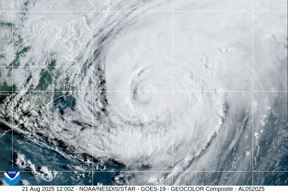
On Wednesday afternoon as it neared our coastline, hurricane-force winds extended more than 100 miles from the center, with tropical storm-force winds up to 265 miles away. That ensured Erin would have an impact on our immediate coastline, even with the eye remaining some 200 miles east of Cape Hatteras on Thursday morning.
Anticipating the potential for damage from a distance, officials issued a mandatory evacuation order for parts of Hatteras and Ocracoke islands beginning last Sunday, and the National Weather Service repeatedly warned that Erin would be a long-duration event.
While the full damage will take longer to assess, this summary includes an early round-up of Erin’s main impacts in North Carolina, as well as a historical perspective about the latest storm to affect the Outer Banks.
Winds, Waves, and Washouts
Unusually among our recent tropical storms, including Chantal earlier this summer, Erin wasn’t a rainmaker in North Carolina. With the rain bands staying mostly offshore, rainfall totals were limited to a few hundredths of an inch at Cape Hatteras early on Thursday morning.
Erin was more of a windmaker, with tropical storm-force gusts observed from Cedar Island through Elizabeth City. Gusts reached up to 51 mph at the Hatteras Marina and 47 mph at Oregon Inlet.
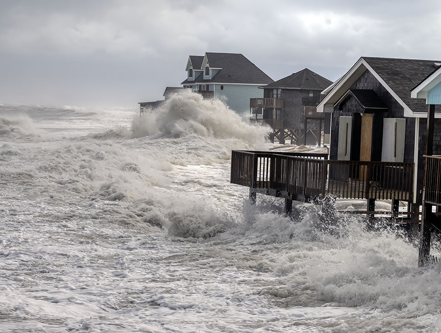
Those stiff northerly winds churning up 15 to 20-foot waves offshore, on top of the existing currents from that direction that constantly scour away east-facing parts of the Outer Banks, meant that overwash and erosion were Erin’s primary impacts.
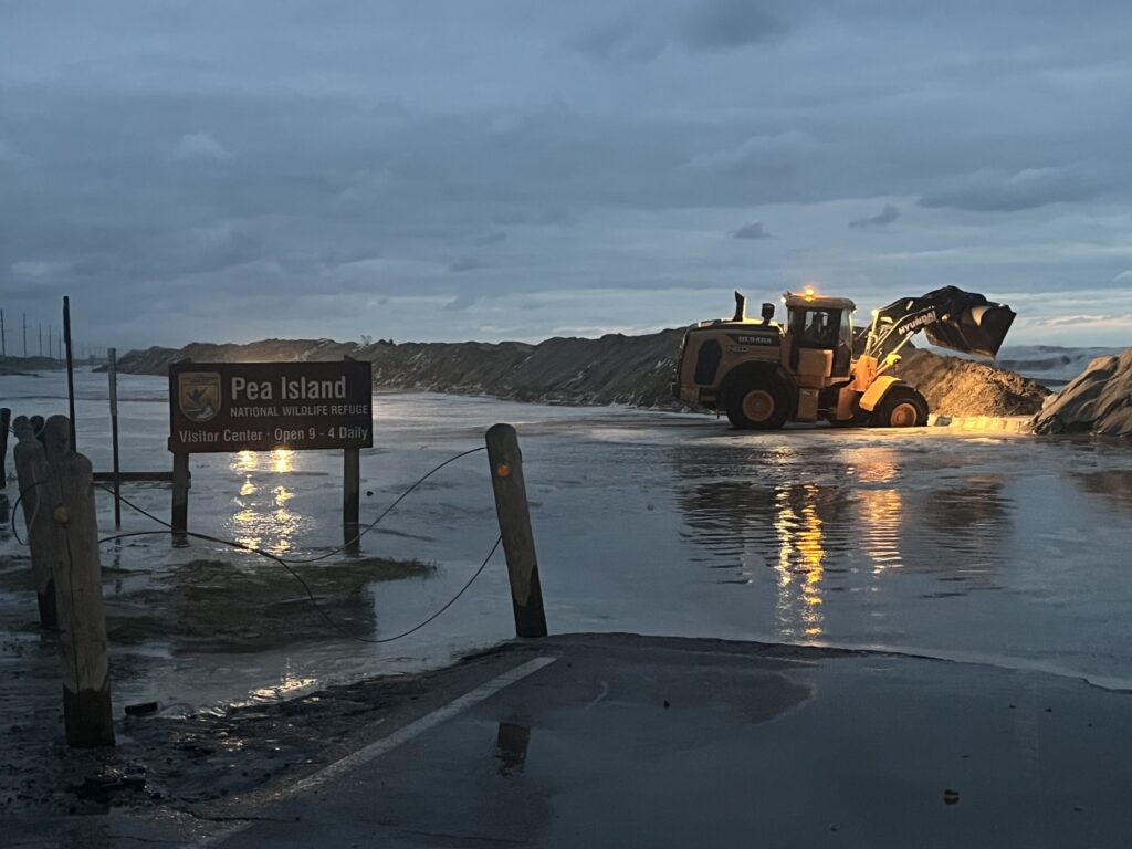
Leading up to the high tide on Tuesday afternoon, overwash began along Highway 12 in Buxton, and by Wednesday night, the entire road was closed with many stretches underwater between Oregon Inlet and Hatteras Village.
The storm surge peaked during Thursday evening’s high tide. The ocean in Duck reached 7.04 feet above sea level, which was the fifth highest crest on record there, exceeding the level from August 1999 when Hurricane Dennis approached.
Even on its way away from the coast, Erin’s threats continued into Friday. Large waves behind the storm, combined with weakened dune structures, resulted in two more dune breaches along Highway 12 early Friday morning, with the potential for significant oceanside flooding throughout the day.
The Latest Coastal Clipper
As we noted earlier this month, North Carolina has not had a direct landfalling hurricane in more than five years, since Hurricane Isaias in August 2020. Erin didn’t quite break that streak, but it was a reminder that despite the spate of inland impacts in recent years, our coastline is still a hot spot for hurricanes.
The last storm with significant impacts along our Outer Banks was Hurricane Dorian in 2019, which produced a devastating soundside storm surge. Areas such as Ocracoke saw some soundside flooding during Erin, but not at the same scale as Dorian produced.
Erin’s oceanside impacts conjured up memories of Hurricane Isabel in 2003 and Hurricane Irene in 2011, each of which went a step beyond basic overwash and carved out new inlets along the Outer Banks. And like Isabel, Erin was a Category-5 earlier in its life, with the high surf from its stronger past reaching our coastline in the days leading up to the storm’s arrival.
Erin’s track was perhaps most similar – but fortunately, with less damage – to 1993’s Hurricane Emily, which was a Category-3 when its eyewall grazed Cape Hatteras. Emily damaged 553 homes and displaced a quarter of Hatteras Island’s permanent population.
Most of the state will remember Erin as only a close call on the cusp of fall – a strong storm steered away just in time by a cooler high pressure system building in.
But for the Outer Banks, Erin was the most recent sign of the power of the tropics and its wave-whipping, sand-shaping fury along that most delicate strip of our state’s coastline.