The first tropical system of the season to affect North Carolina produced locally heavy rainfall and flooding in parts of the Piedmont and Sandhills.
Tropical Storm Chantal wasn’t particularly intense or long-lasting, but it had big impacts in areas such as Alamance, Chatham, Moore, and Orange counties where the heaviest rain occurred.
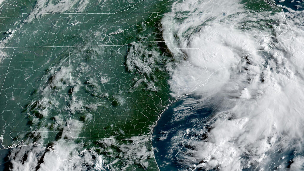
Like many early-season tropical storms, this system developed along a stalled frontal boundary sitting over the warm waters of the Gulf Stream. On July 5, sustained winds around the center of circulation off the Georgia coast reached the tropical storm threshold 40 mph, making it the third named storm in this Atlantic hurricane season.
While nearly stationary at first, Chantal was propelled northward between an upper-level low over the Gulf and an upper-level high over the mid-Atlantic. That put it on a collision course with the South Carolina coastline, where it made landfall as a moderate tropical storm with 58-mph sustained winds early on Sunday, July 6.
After moving inland, Chantal quickly weakened to a tropical depression, but packing plenty of Atlantic moisture, it was rain rather than wind that proved to be the primary hazard. Identifying that threat of flooding rains, the National Weather Service included central North Carolina with a risk of excessive rainfall by early Sunday morning.
Rain, River, and Flood Reports
The greatest rainfall totals and worst flooding occurred along the remnant low-pressure track, following and just west of US Highway 1. In the south, that included 4.68 inches on Sunday in Lumberton – its highest daily total since Hurricane Florence in 2018. That rain left the Lumber River rising to minor flood stage.
CoCoRaHS observations in Moore County show as much as 7.45 inches near Pinehurst. The nearby Little River at Niagara Carthage Road also reached its minor flood stage with a crest of 15.74 inches on Sunday night. That heavy rain prompted a state of emergency declaration in Moore County due to concerns about flooded roads and potential dam failures.
In Chatham County, a handful of CoCoRaHS observers measured more than nine inches, including up to 10.37 inches near Pittsboro. On Monday morning, the Haw River near Bynum was at major flood stage at 22.48 feet, apparently breaking its record crest of 21.76 feet from Hurricane Fran in 1996. The state Highway Patrol confirmed a death in Chatham County when an 83-year-old woman’s car was submerged and swept away.
A pair of volunteer CoCoRaHS observers in northern Orange County reported similar Sunday totals of 10.43 inches and 10.49 inches. In central Orange County, the Eno River near Huckleberry Springs, within Eno River State Park, hit its major flood stage with a crest of 23.04 feet, surpassing its previous record of 14.91 feet from March 1989.
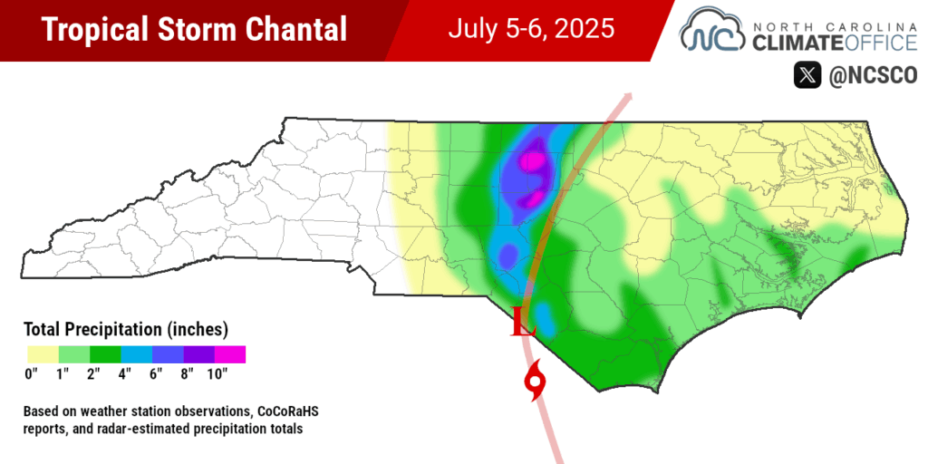
In southern Orange County, a pair of official weather stations reported more than 7 inches of rain. The Duke Forest RAWS station totaled 7.78 inches and our ECONet station at the former Horace Williams Airport in Chapel Hill had 7.65 inches. Both were new daily records for those locations dating back to 2000 and 2001, respectively.
The Burlington airport also set a new daily rainfall record dating back to 2001, with 5.75 inches on Sunday. The Haw River in Alamance County crested in major flood stage at 32.50 feet on Sunday, just shy of its all-time record of 32.83 feet following Fran. Also in the county, a section of westbound Interstate 40 and southbound Interstate 85 was closed near Graham due to the flooding.
Two tornadoes in the state have already been confirmed due to Chantal: one in New Hanover County and another at the Raleigh Executive Jetport in Lee County. The days and weeks ahead will reveal more about the damage, including additional tornadoes, any further fatalities, and the full scale of the storm’s flooding.

A New Year, a Similar Storm
While their meteorological histories were different, Chantal was remarkably similar to Debby last August. Both were slow-moving moderate-strength tropical storms that made landfall in South Carolina before their remnants crossed central North Carolina, depositing Atlantic moisture as heavy rain all along the way.
Debby dropped more than 10 inches of rain in Wilmington while Chantal brought similar totals around Chapel Hill. Parts of the Lumber and Cape Fear river basins saw major flooding from each event, and sections of major interstates – I-95 in Lumberton after Debby, and I-40/85 near Graham after Chantal – were closed following flooding from both storms.
And as with Debby, Chantal didn’t produce the sort of broad-brush heavy rainfall totals as storms like Matthew and Florence, but its more localized impacts were still extreme, damaging, and deadly.
The calendar shows that we’re barely in July, which means Chantal was also an early arriver. And with the expectations of near- to above-normal activity in the Atlantic this year, the chances are strong that Chantal won’t be our only tropical encounter in 2025.
Climatology tells us that the Coastal Plain is a common target for hurricanes, and after last fall’s hard hit from Hurricane Helene in the Mountains and Chantal’s heavy rain and flooding in the Piedmont and Sandhills, it’s clearer now than ever that nowhere in the state is immune to tropical impacts.