Our latest climate summary takes a focused look at the recent dry conditions across much of the state.
Despite increasing activity in the tropics last month and several storms passing close to North Carolina, most of the state escaped September without much rainfall to show from tropical systems or otherwise.
The main exception was parts of the Mountains and Foothills that picked up their monthly allotment of rain and then some from the remnants of Hurricane Irma.
Even in the scattered parts of the Coastal Plain that received above-normal rainfall, most of that fell in the first half — or even on the first day — of the month. The final two weeks of September were dry across the board.
Last month’s statewide average rainfall was 4.52 inches — about 0.2 inches below the 1981 to 2010 average — making it the 55th-wettest (or 69th-driest) September since 1895.
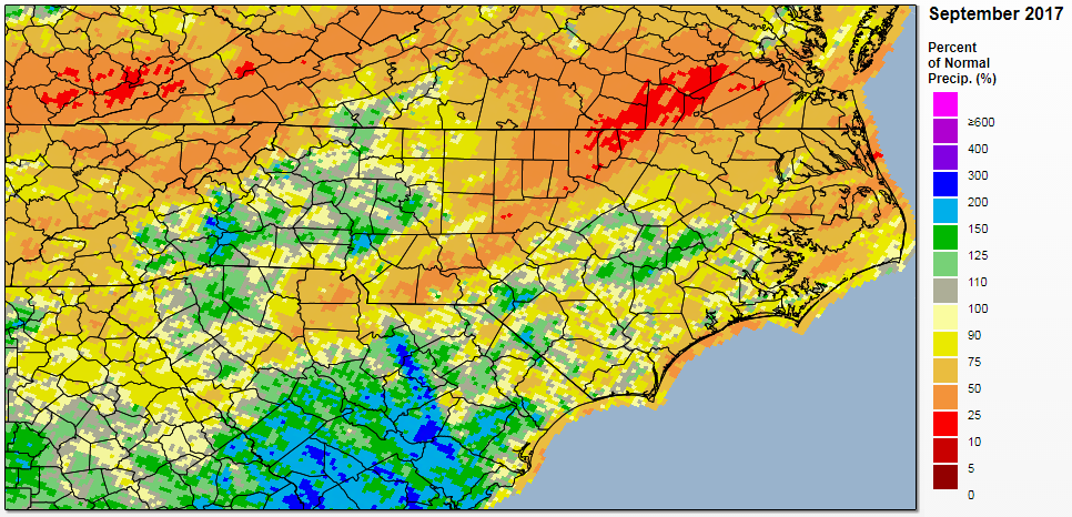
The driest parts of the state were substantially more below average. Along a line running from Wadesboro through Durham and Oxford, most sites received less than half of their normal September rainfall. Henderson in Vance County received just 1.15 inches of rain all month, a full 4 inches below normal.
Those parts of the Piedmont were already classified by the US Drought Monitor as Abnormally Dry throughout the summer, so will we soon see the return of drought conditions for the first time since the end of last winter’s drought in the Mountains?
To get a feel for how conditions look across the state, let’s see what a number of drought indicators say about our conditions.
Rainfall Deficits
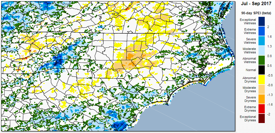
Since we ended the spring with one of our wettest Mays on record, conditions have gotten progressively drier for most of the Piedmont and Coastal Plain. In the past three months, the Greensboro Airport is 6.3 inches below its normal precipitation, and since July 1, our Siler City ECONet station has reported just 1.89 inches of rain — nearly 10 inches below normal.
We can estimate the water balance — the difference between incoming moisture from rainfall and outgoing moisture from evaporation and transpiration — using the Standardized Precipitation-Evapotranspiration Index (SPEI). As the map below shows, the SPEI over the past 90 days indicates dryness in parts of the Piedmont equivalent to Moderate (D1) to Severe (D2) Drought conditions.
Temperatures
If it wasn’t for our moderate temperatures in September, that dryness would likely be much more widespread and severe. The statewide average temperature over the past month was 69.74°F, which ranks as our 54th-coolest September out of the past 123 years.
As temperatures steadily decline this fall — between September 15 and October 15, our average high temperature drops by almost 10 degrees — the evaporative stress due to warm weather will decrease. As we saw in September, that could help pump the brakes on worsening or expanding dryness.
Streamflows and Groundwater
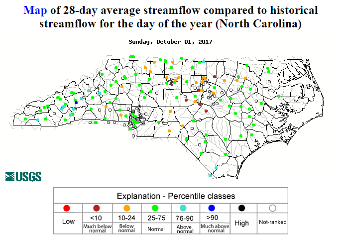
The lack of recent rainfall is reflected in the streamflow conditions across the Piedmont. The 7-day average streamflows are at below normal to much below normal levels across most of the Piedmont and parts of the Coastal Plain.
Over the past 28 days, though, the low streamflows aren’t as prevalent. The only sites with much below normal levels — less than the 10th percentile for this time of year — are along that corridor of maximum dryness in the east-central Piedmont.
Longer-term indicators such as groundwater levels are in even better shape. All but one of the USCRN groundwater wells across the state are near- or above-normal, with the shallower Champion well in Haywood County the only one at below-normal levels.
Reservoir Levels
The lack of rainfall and low streamflows mean reduced inflows into reservoirs. Last week, Falls Lake had just 3% of its normal median net inflows, and its elevation was about 1.5 feet below the guide curve target.
It’s a similar story for most reservoirs across the Piedmont, although the low levels aren’t as concerning as if this was happening during the spring or summer. That’s because, usually beginning around Labor Day and ending sometime in December, operating agencies steadily decrease reservoir levels from the full summer pond to a lower winter elevation.
While the dry weather may mean reaching those winter targets sooner, water supply is not a concern at the moment.
Agricultural Reports
Crops like corn and soybeans are all fairly mature by this time of year so they’re not quite as sensitive to dry weather, and dry conditions help farmers get in their fields to harvest vegetables and tobacco.
Rain this time of year is mainly needed for hay and pasture growth, and overall, last week’s USDA Weather & Crops Report suggests good progress is being made despite the drier weather. The worst conditions reported were stress on soybeans in Person County, which was among the driest spots over the past month.
CoCoRaHS Condition Monitoring Reports
Recent reports from around the state suggest widespread mildly to severely dry conditions, most of which have emerged in the past few weeks. An observer from Durham County noted that “shallow-rooted shrubs are showing wilting” as well as an “early yellowing/browning of leaves”.
Because fall is our driest season, it can be tough to tell the difference between typical seasonal impacts and drier-than-normal conditions. A Burke County observer described this challenge, noting that some trees and annual plants have already lost their leaves and blooms while others are following their usual progression and some some of their flowering plants are still doing well.
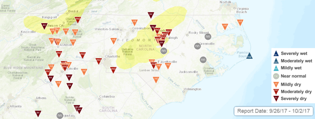
These mixed indicators show how varied conditions are across different time scales. In the very short term (over the past few weeks), North Carolina has been exceptionally dry. For the past season, we’re a little dry, but that dryness is primarily confined to a few counties in the central Piedmont. Over longer timescales dating back six months to a year, we’re at near-normal precipitation or even on the wet side of normal.
So what should we expect to see in the coming weeks?
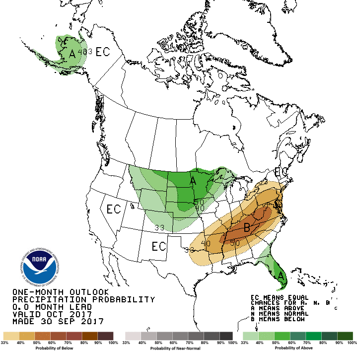
For starters, the forecast provides little hope for a pattern shift. The Climate Prediction Center calls for increased chances of above-normal temperatures and below-normal precipitation over the next one month and three months.
Another week or two of bone-dry weather will almost certainly see the expansion of Abnormally Dry conditions, most likely across the northwestern Piedmont and northern Coastal Plain.
We can’t rule out Moderate Drought conditions appearing on the US Drought Monitor’s assessment for North Carolina, although they’re not likely to be widespread due to the aforementioned factors. The first places that would see drought return would be the central Piedmont, especially in parts of Chatham, Lee, and Moore counties.
With the growing season nearing an end — our first fall freeze typically happens within the next month or so — the impacts of continuing dry weather would be fairly limited for agriculture.
It’s also not likely to significantly affect the fall foliage, at least not in a negative way. A bit of dryness this time of the year can actually help the leaf colors “pop” just before they fall, so trees that have hung onto their leaves may offer up a more vivid show than usual.
As leaves are falling and raindrops aren’t, keep a close eye on conditions in your backyard and respond accordingly, whether it’s using water efficiently, not burning when conditions are risky, or even setting out some water for thirsty animals and migrating birds passing through.