When residents and even forecasters in central North Carolina woke up on Saturday morning, they had little idea that a rare rainfall event awaited later that day. After all, the morning cloud cover hardly threatened a stormy afternoon. But clearing clouds, warming temperatures, and several storm-specific ingredients resulted in extreme precipitation totals over a small time period for parts of the Triangle and areas farther east.
Storms Take Shape
As the first storms fired up just after 3 pm, the first ingredient for heavy rainfall became apparent. The storms formed along the I-95 corridor, which runs from southwest to northeast, but they were also moving to the northeast. That meant places like Edgecombe County received relentless rainfall all afternoon as the storm cells moved through one-by-one.
One such storm cell formed over Johnston County, and while it was a rainmaker in its own right, producing totals of three or more inches, it unleashed another key ingredient for even heavier rain across the Triangle. Downdrafts — or rapidly sinking air — from that thunderstorm cell produced an outflow boundary, which separated the rain-cooled air associated with the thunderstorm from the warm, unstable air away from the storm.
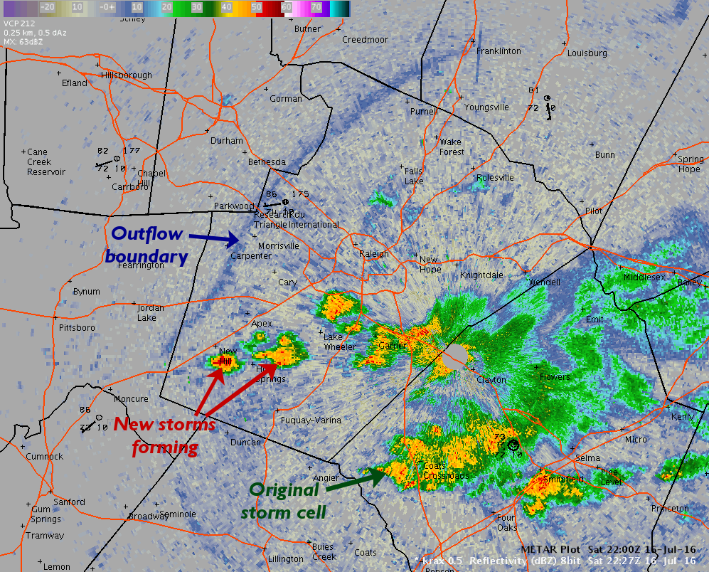
The outflow boundary flowed away from the Johnston County thunderstorms toward the northwest over Wake County. Acting like a mini cold front, the lift along the outflow boundary helped to trigger new thunderstorms. The atmosphere on this day had plenty of moisture present, which meant heavy rain in Raleigh and Cary from these storms. However, this was just round one of the rainfall.
The final ingredient for heavy rains came in the form of a separate line of storms moving eastward across the Piedmont. As it collided with the outflow boundary, it provided some extra lift to supercharge storm formation. New cells popped up in Durham and Wake counties and continued moving to the northeast, so locations receiving rainfall saw plenty of it in a short time period.
All of these ingredients led to heavy rains that spiked river levels, created flash flooding in streets and low-lying areas, and even required several rescues of people who were stuck in their cars amid the high water.
Rainfall Totals
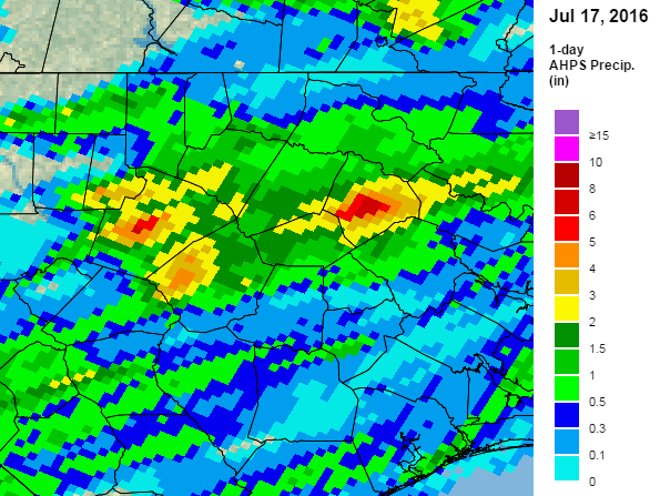
Across the region, the storms produced some truly astounding rainfall totals. Radar-based estimates showed more than four inches of rainfall over swaths of Durham, Wake, Johnston, and Edgecombe counties, with even greater local amounts.
One volunteer CoCoRaHS observer in Cary reported 7.52 inches, and several other observers and weather stations along the primary track of the storms reported five inches or more. Our Reedy Creek ECONet station reported 5.77 inches of rain in a six-hour period.
In Edgecombe County, our ECONet station near Rocky Mount reported 8.96 inches of rain over the course of 10 hours, with as much as 4.54 inches falling in a single hour. For Rocky Mount, that’s the second-highest daily precipitation total on record since 1914, trailing only September 16, 1999, when Hurricane Floyd brought a daily total of 16.55 inches.
Return Frequencies
Along with seeing where these precipitation totals rank among the historical records, we can also look at another statistic called the return frequency to assess just how rare certain precipitation amounts are over certain periods of time.
Using the National Weather Service’s Precipitation Frequency Data Server, we can check the return frequencies for the amounts in this event. For central Raleigh, 5.77 inches of rain over a six-hour period has a 100-year return frequency. For Rocky Mount, nine inches of rain over a 12-hour period is a 200-year to 500-year precipitation event.
So that means we’re in the clear of heavy rain events like this one for a few hundred years, right? Not exactly. Mother Nature pays little attention to the calendar, so we could have a similar event next week or next year or next decade, then go 200 years without another such occurrence. For that reason, these return frequencies are best interpreted as averages.
Alternatively, you can convert the frequency to a fraction and think of it as the odds of having such an event in a given year. In this example, Raleigh would have a 1 out of 100, or 1%, chance of seeing 5.77 inches of precipitation in a six-hour period during a given year.
The rarity of these totals speaks to how impressive the ingredients were that produced them: namely, the combination of the position and movement of storms and outflow boundaries in a moisture-rich environment. These ingredients converged over a few relatively small areas and gave those locations more than a month-and-a-half worth of precipitation in one afternoon. Meanwhile, surrounding areas that weren’t in the path of the train of storm cells saw almost no rain at all!
For that reason, this event also serves as a good — and for some places, a very soggy — example of how difficult summertime precipitation forecasting can be.