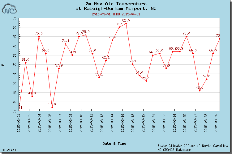
We put the winter behind us last month as temperatures regularly hit the 60s and 70s, although we did endure some cooler days as well.

Topsy-Turvy Temperatures
A combination of warm and cool periods during March averaged out to near-normal temperatures across North Carolina. The statewide average temperature of 49.9°F ranked as the 56th-warmest March in the past 121 years.
After a cool finish to February, we climbed into the 60s and 70s in the first week of March. Our temperature rollercoaster then dropped our highs back into the 30s on March 5th, before we rose into the 70s again a few days later. The variable conditions continued throughout the month, as our periods of warmth were punctuated by cold frontal passages, bringing temperatures in the 40s and 50s.
In the mean temperature rankings, the warm weather strongly outweighed the cool in several spots. Asheville had its 6th-warmest March in the past 64 years, with average temperatures four degrees above normal. Charlotte’s average temperatures were 3 degrees above normal, making it the 16th-warmest March out of the past 74 years. Lincolnton and Hickory were both two degrees above normal.
A few sites in the northern Coastal Plain came in on the cool side of normal. Elizabeth City, Plymouth, and Greenville each had temperatures average one degree below normal, and Edenton came in two degrees below normal to give the 44th-coldest March in 114 years.
Dry Conditions Continue, But Still No Drought
The statewide average precipitation of 3.38 inches made it the 37th-driest March on record. Unlike the winter months, when there was a clear divide between wet weather in the east and dryness in the west, almost the entire state was drier than normal last month. The driest area was the southern Piedmont, where many spots received less than half of their normal March precipitation.
The only major rain event came on March 5th during a cold frontal passage, which brought a half inch to an inch of rain statewide. After that, a handful of minor events generally brought less than half an inch each. With that in mind, it’s not surprising that the western half of the state finished the month more than an inch and a half below their normal March precipitation.
That precipitation deficit, along with streamflow levels below the 10th percentile, led the US Drought Monitor to expand Abnormally Dry conditions across the western third of the state. It’s been almost two full years — since April 23, 2013 — since any part of the state was officially classified in drought conditions. However, if the recent lack of rainfall continues as the springtime agricultural demands increase, we may be lucky to finish this April without seeing a return of drought to North Carolina.
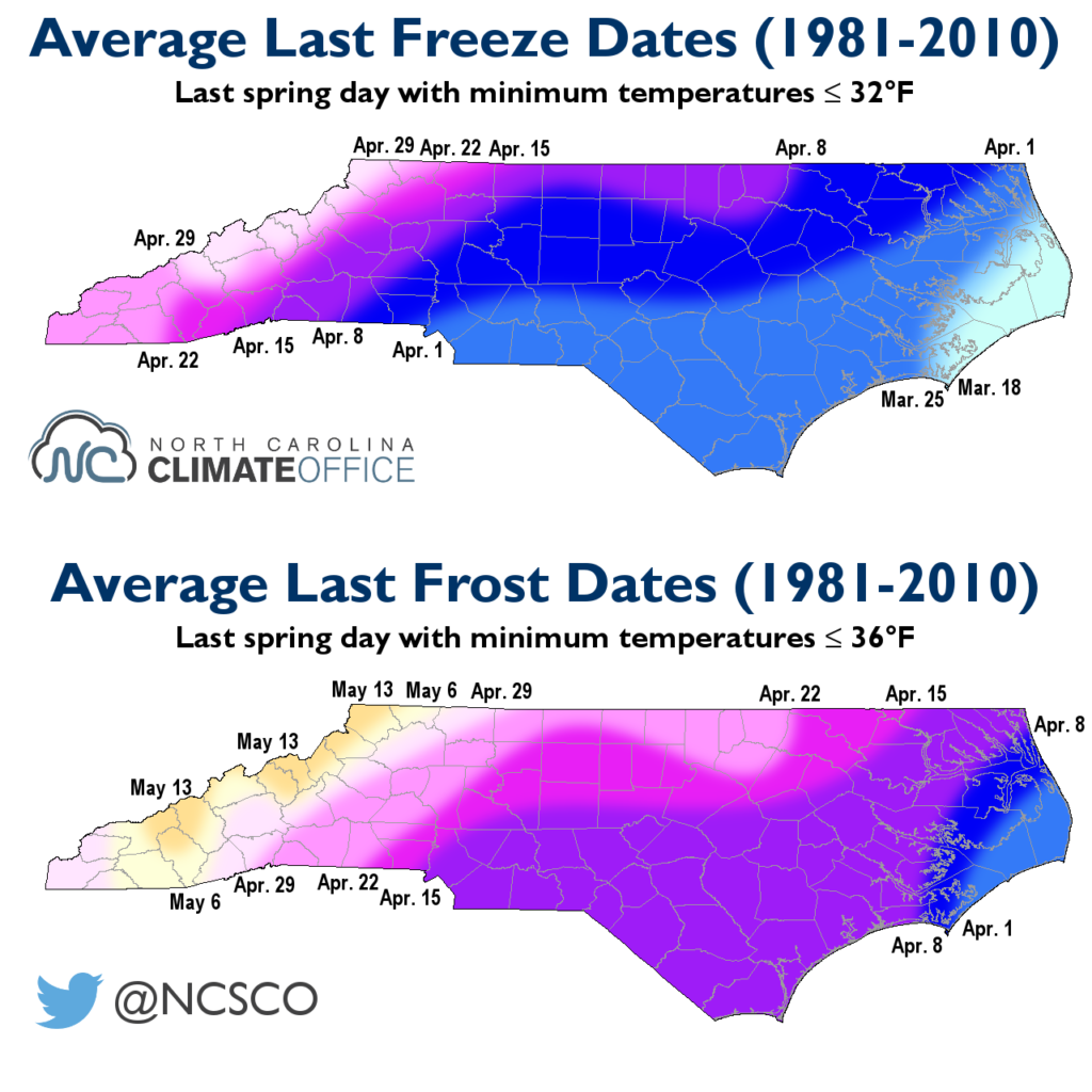
Was our Late-March Freeze the Spring’s Last?
A cold morning on March 29 resulted in a hard freeze across the state as temperatures dropped into the 20s and below. That freeze came near the normal last spring freeze dates for the eastern half of the state (shown below, in the top map), although the mountains typically see a freeze in the second half of April.
The Climate Prediction Center’s latest 8-14 day forecast suggests elevated odds of above-normal temperatures through the middle of the month. Historically speaking, it’s not unusual to have a freeze after that, but it is fairly rare. The final spring freeze occurring after April 15 has happened just 15 times out of 71 years in Raleigh (21% of the time), 23 times out of 112 years in Greensboro (21% of the time), and 8 times out of 74 years in Charlotte (11% of the time).
It’s more likely that we may still see a late-spring frost. As we discussed in our fall frost and freeze climatology, a frost occurs when plant-level temperatures are at or below freezing, which can happen when the air temperatures measured 2 meters off the ground are a few degrees above freezing.
Once we get past any potential late-season frosts and freezes, and if we can see some April showers across the state, we’ll be all set for some May flowers as the spring continues.