For those cold winter days when the wind seems to bite at your skin, meteorologists have developed a way to quantify the hold that the cold has on you.
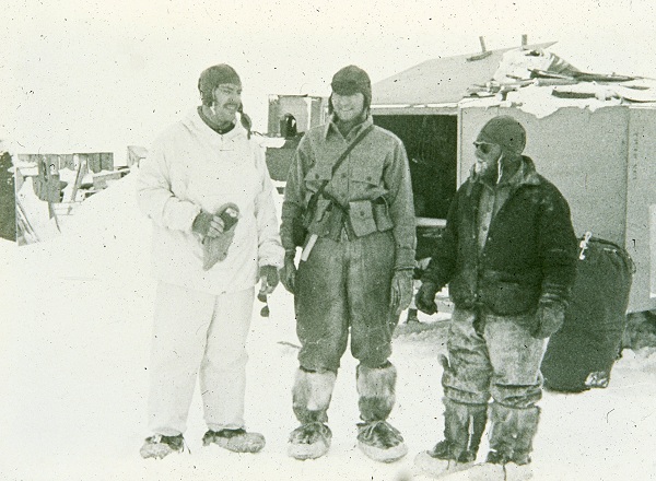
The first wind chill estimates were created by Paul Siple and Charles Passel, two Antarctic researchers in the 1940s who measured the cooling rate of a bottle of water they hung near their weather instruments. However, their initial equations gave the wind chill as a rate, with the units of watts per square meter — the same units we use to measure solar radiation. Because of this, it wasn’t very intuitive to use or interpret, so they eventually developed an equation for a wind chill temperature that would be used for more than 50 years.
Improving on the simple equations developed by Siple and Passel, the National Weather Service unveiled the currently used Wind Chill Temperature index in 2001. This represented a huge advancement in the science since the Antarctic experiments of the ’40s. Since water in a bottle doesn’t cool in the same way that people do, the Wind Chill Temperature incorporates the resistance of human skin and also includes the influence of metabolic heat generation — in other words, the fact that our bodies burn fuel to regulate internal temperature.
The other major adjustment was to estimate the wind speed at average human face height by reducing the 10 meter wind down to 5 feet. Their final, simplified equation is given below, where T is the air temperature in Fahrenheit and ws is the wind speed in mph.
Wind Chill Temperature = 35.74 + 0.6215*T – 35.75*ws0.16 + 0.4275*T*ws0.16
So how do we interpret the Wind Chill Temperature? Remember that the original wind chill was given as a cooling rate. As the wind speed increases, our skin cools down at a faster rate than our bodies can burn enough fuel to warm it back up. That’s why it feels colder than the actual air temperature when the wind is blowing.
Since the Wind Chill Temperature was designed for humans, it has no real meaning for other things. Some researchers in the 1970s found that animals like cows and sheep don’t lose heat as quickly as humans in windy conditions due to the insulation provided by their hair or wool. And just as the Wind Chill Temperature designed for humans doesn’t work well for animals, it also doesn’t have a physical meaning for inanimate objects. For example, if the air temperature is 40°F and the Wind Chill Temperature is 30°F, water won’t freeze and objects won’t behave as if they’re below freezing. They may cool more rapidly when exposed to the wind, but will never drop below the actual air temperature due to the wind alone.
The wind chill climatology varies widely across North Carolina. The table below shows the average number of hours per year with wind chills below 20 degrees, 0 degrees, and -20 degrees Fahrenheit, based on data from several long-term weather stations between 1981 and 2010.
| Location | Hours Below 20°F | Hours Below 0°F | Hours Below -20°F |
|---|---|---|---|
| Cape Hatteras | 53 | 2 | 0 |
| Wilmington | 72 | 2 | 0 |
| Charlotte | 121 | 5 | 0 |
| Raleigh | 152 | 7 | 0 |
| Greensboro | 229 | 9 | 0 |
| Asheville | 404 | 39 | 3 |
It makes sense that the wind chill is lowest at mountain locations such as Asheville, where cold temperatures and high winds are fairly common during the winter. Sub-zero wind chills are rare, with even Asheville seeing only about 39 hours per year with a wind chill below zero. Raleigh averages about 7 hours of below-zero wind chill per year, but the last time that happened was early in the morning of December 20, 2004, when temperatures hovered around 13 or 14 degrees with a west-northwesterly wind of 10 to 15 mph.
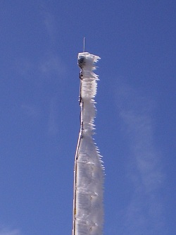
North Carolina’s wind chill champion is probably Mount Mitchell, the highest point east of the Mississippi River. Our ECONet station on Mount Mitchell has only been there since 2008, and since then it has had several winters where its sensors stopped reporting data because of ice buildup, high winds or the tower toppling over. The data we do have is very impressive, though. During the 2010-11 winter, our Mount Mitchell station saw 1,830 hours — the equivalent of about two and a half months — with a wind chill at or below 20 degrees. That included 496 hours with sub-zero wind chills and even 96 hours with wind chills at or below -20 degrees. At that wind chill, frostbite can set in within 15 minutes.
Of course, most of us will never see conditions that harsh, especially in North Carolina. But if you do feel a chill in the air — and on your skin — this winter, just consult the Wind Chill Temperature to see how cold it really feels.
Sources:
- August 2001 Press Release from the National Weather Service
- Wind Chill from the National Weather Service’s Grand Junction office
- Wind-Chill Effect for Cattle and Sheep by D. R. Ames and L. W. Insley, 1975, Journal of Animal Science
- Wind Chill Temperature Index from the Wind Energy Institute of Canada