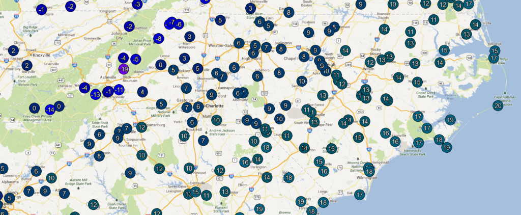
We recently saw — and felt — some of the coldest temperatures in more than a decade all across the state. On Tuesday morning, much of the coast dropped into the teens, including 17°F in Wilmington and 13° in Elizabeth City. Temperatures reached digit-numbing single digits in the Piedmont, as Raleigh hit 9°, Charlotte hit 6°, and Greensboro had a low of just 5°. And in the mountains, temperatures bottomed out in the negatives, including a -1° low in Asheville, -8° in Boone, and a bone-chilling -18.8° at Mount Mitchell, where wind speeds greater than 45 mph meant wind chills of up to -55°F.
This intense cold air outbreak has been largely blamed on the indomitable-sounding “polar vortex”, but that’s just one of the factors that made Tuesday, January 7 such a rare, chilly day. Here’s a look at three of the main causes that worked together to bring us such cold temperatures.
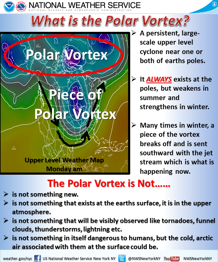
The Polar Vortex
Rarely does the polar vortex get the attention it’s received this week, and it’s easy to imagine it as something out of a sci-fi movie. But as this infographic from the New York City National Weather Service office nicely explains, the polar vortex is a feature that’s always present in the upper atmosphere. As the name implies, it’s usually centered around the North Pole. However, in this week’s cold event, the polar vortex dipped farther south — centered over northern Michigan — than we’ve seen in many years, bringing a frigid polar airmass along with it.
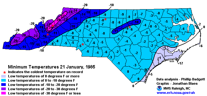
One of the last times we saw the polar vortex reach that far south was on January 20, 1985. North Carolina weather buffs will remember that the next day — January 21 — is often called “The Coldest Day” because of the record low temperatures that were set all across the state that morning, including the statewide record of -34°F at Mount Mitchell. As this side-by-side comparison of the upper-level pattern for the 1985 and 2014 cold events shows, there are notable similarities in the polar vortex strength and position in these events. If the polar vortex had been slightly stronger and slightly farther south in this week’s event, we could have conceivably challenged some of those long-standing records.
Airmass Moderation (or Lack Thereof)
Every winter, a handful of Arctic airmasses drop into the U.S., and as they move south, the air generally warms up as it moves over warmer land. However, preceding this week’s event, much of southern Canada and the U.S. Midwest were covered in a blanket of snow. That meant those locations were colder, which did not let the Arctic airmass warm up (or moderate) much as it moved south. Essentially, we got air-mailed a late Christmas present straight from the North Pole in the form of cold air that changed very little on its journey to our doorstep.
Clear Skies Overnight
When the sun set on Monday night, skies were clearing across North Carolina, which gave ideal conditions for cold minimum temperatures. At night, some of the previous day’s stored heat energy is radiated away by the earth. When clouds are present, they can trap some of that heat near the surface. But when skies are clear, that heat is free to escape into space. This process, called “radiative cooling”, allows temperatures to drop until sunrise, when the earth again begins to receive solar radiation and store heat energy.
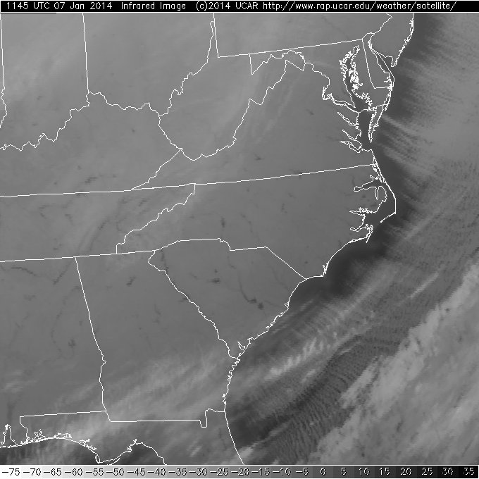
As the infrared satellite image (right) from Tuesday morning shows, skies were clear all across the Carolinas, with the closest cloud cover just off the coast and over southern Georgia. The dark spots you see across North and South Carolina are lakes, which appear darker than the surrounding land on this image, indicating a warmer temperature. That’s another good indication of the radiative cooling and associated heat loss from the land overnight.
Quick Assessment
Those three factors combined to make this one of the coldest days of the 21st century. To make this cold air outbreak even more impressive, it was achieved with no snow on the ground in North Carolina. Cold temperatures are fairly common after snow events because snow keeps heat from escaping from the surface, and most of the daytime solar radiation goes toward melting the snow instead of warming the earth. However, to achieve the cold temperatures we saw this week with no snow present was an impressive and rare feat. The last time Raleigh saw single-digit temperatures with no snow on the ground was nearly 20 years ago, on January 20, 1994.
Also, afternoon highs on Tuesday struggled to reach the 20s statewide and barely made it to 30 in Wilmington. Even on the Coldest Day in 1985, daytime temperatures warmed up to 33 in Charlotte, 38 in Raleigh and 59 in Wilmington. On Tuesday, though, a steady strong wind out of the west meant a continuous feed of cold air, which kept temperatures chilly even on an otherwise sunny day. Although it may not have matched the extreme lows from January 21, 1985, it’s likely that January 7, 2014, will become one of the benchmarks to compare our cold winter days against.