In the past three weeks, afternoon thunderstorms have brought the usual combination of heavy rain, thunder, and lightning, but they’ve also packed an extra punch. Since April 23, the National Weather Service has issued 179 storm reports for hail in North Carolina, from Cedar Island in the east to near Asheville in the west.
So what is hail and why is it so common during this time of the year?
Let’s start with the first question. A hailstone is born when small liquid droplets in clouds freeze on contact with condensation nuclei — things like dirt, soot, or salt particles in the air. This creates a small icy pellet.
Strong updrafts, or fast-moving rising air, keep these pellets suspended in the storm clouds where additional droplets can accumulate on the surface, making them grow even larger. Once the updraft can no longer support the weight of the growing hailstones, they fall from the cloud to the ground.
This happens after a different amount of time in each cloud depending on the strength of the updraft. But when atmospheric conditions are right, hailstones can grow to several inches across.
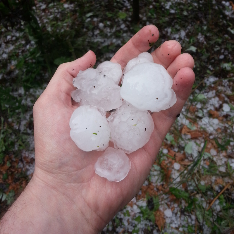
The recent storms produced hailstones up to 2.5 inches in diameter, or roughly tennis ball-sized, in Alamance and Wake counties, and we have historically seen hail nearly double that size in North Carolina. There are a handful — make that a large, icy handful — of 4.5-inch hail reports on record, most recently from a storm on May 24, 2000, near Dysartsville in McDowell County.

Atmospheric Ingredients for Hail
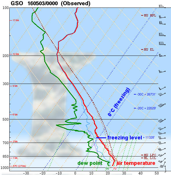
Of course, not every storm produces hail since they don’t all have the right environment for hail formation. Three main factors make hail more likely. We can identify them on the atmospheric profiles of temperature, dew point, and winds from a weather balloon sounding taken in Greensboro earlier this month on a day with widespread hail reports across the Piedmont.
- Within the clouds, air must be below freezing to give the icy hailstones a chance of forming. A low freezing level provides more vertical real estate for hailstones to develop.
In this example, the temperature profile dropped below freezing at an altitude of 11,328 feet. Although the cloud base was a bit below this — at the Lifting Condensation Level around 3,200 feet up — that still left a lot of room in the mid- and high levels of the clouds for hailstones to bounce around and grow.
- When the atmosphere is unstable with cold air sitting above warm air, that warm air can rise rapidly, producing the strong updrafts needed to keep developing hailstones suspended in the air. In this case, that instability is seen by the warm surface temperature and dew point, with a significant decrease in temperatures, or lapse rate, just off the ground.
The Convective Available Potential Energy (CAPE), a measure of instability, was more than 2,000 Joules per kilogram on this afternoon in Greensboro. That’s a high value that indicated plenty of unstable air was present to fuel strong updrafts.
- Along with rising air and updrafts, thunderstorms also have sinking air and downdrafts. If a downdraft forms in the same location as the updraft, it can slow the rising motion and effectively stop hail formation. However, when wind shear is present and upper-level winds are stronger than those at low levels, the downdraft is offset from the updraft and hail can keep growing unimpeded.
On this day in Greensboro, surface winds were southerly at around 10 knots (12 mph) while the winds four miles up exceeded 45 knots (52 mph) from the southwest. That amount of wind shear was plenty to displace the downdrafts away from the updrafts.

North Carolina’s Hail Climatology
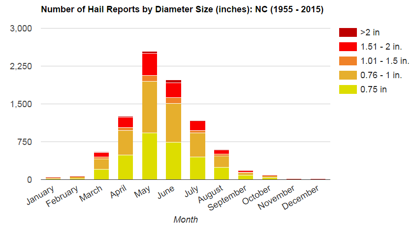
Hail is most common during the late spring and early summer months because we’re in something of a Goldilocks zone with those first two factors. Temperatures aloft still tend to be cold enough to support hail growth while surface temperatures can be warm enough to provide the necessary instability.
Climatologically speaking, North Carolina has seen the most hail in the month of May, with more than 2,500 confirmed hail reports since 1955. That’s twice as many hail reports as we’ve historically had in April, which shows the importance of the warm, moist surface conditions and instability.
A few other factors including elevation can also make hail more likely. Higher-elevation locations are closer to the cloud base and freezing level, so falling hail has less warm air to fall through on its way to the ground. Although we don’t often consider North Carolina’s highest mountains a haven for severe weather, the recent storms left hail covering the ground in Beech Mountain, Black Mountain, and Mount Mitchell, as well as hail drifts in Banner Elk.

Hail, Snow, Sleet, and… Graupel?
While a layer of hail can whiten the ground and even pile in drifts like snow, there are some important distinctions between hail and frozen wintry precipitation types.
Hail develops and falls from clouds as an icy pellet. Despite the warm ambient temperatures beneath the clouds, hail can still reach the ground in a frozen form, although the warm air tends to melt the outer layers of the hailstones. Snow, on the other hand, falls from clouds as flakes or crystals and stays in that frozen form all the way to the ground.
During the winter, we can also see precipitation fall as ice pellets or sleet. That forms when snowflakes fall into a warm layer and melt into droplets, then refreeze as pellets in cold air near the ground. If this cold air layer is very shallow, it will instead reach the ground as a liquid drop but freeze on contact with the surface — the dreaded phenomenon of freezing rain.
One other interesting but rare hybrid precipitation type falls somewhere between snow and hail. Graupel forms when supercooled droplets freeze onto falling snowflakes and reach the ground as small pellets. Because of these similarities, graupel is sometimes called soft hail or snow pellets.
Of course, there’s another key difference between hail, snow, sleet, and graupel. The latter precipitation types aren’t likely to leave a dent in your home or car when they fall to the ground!