Debby’s Deluge, Late-August Heat Ends a Summer of Extremes

August was wet for most of North Carolina thanks to Debby’s rainfall, while temperatures peaked in the final week of the month. That ended a roller coaster summer with extremes of all sorts.
Doused by Debby, but Dry in the West
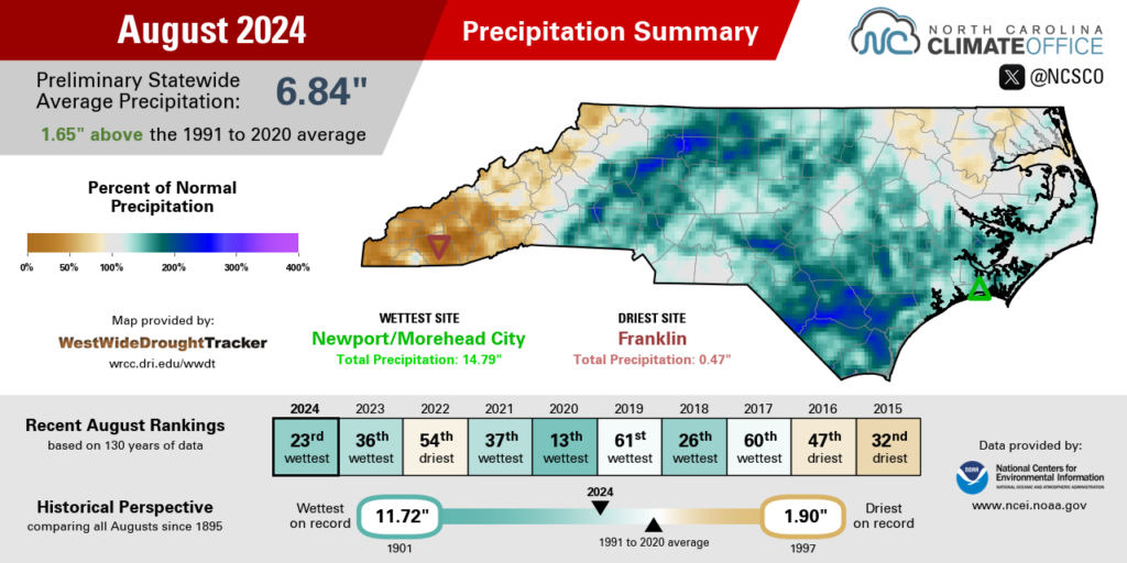
Our August precipitation was dominated by Tropical Storm Debby’s contribution, which single-handedly made for a wetter-than-normal month. The National Centers for Environmental Information (NCEI) reports a preliminary statewide average precipitation of 6.84 inches, which ranks as the 23rd-wettest August since 1895.
The month started with scattered showers along a cold front on August 3, with locally heavy totals of up to 2.96 inches in Asheville. But for eastern areas, that was just the appetizer before even heavy rain arrived the following week.
Debby’s slow slide up the coastline from August 6 to 9 brought more than 8 inches of rain in far southeastern North Carolina and widespread totals of at least 4 inches in the Piedmont and central Coastal Plain.
The extreme amounts and extended duration of that rain meant a prolonged period of high water levels, even well after the storm was gone. The Lumber River at Lumberton spent two full weeks in at least minor flood stage and almost a week at major flood stage. Its crest of 21.48 feet on August 12 was the third-highest recorded at that location, behind only the crests from Florence and Matthew.
Fortunately for those storm-soaked areas, Debby was followed by several weeks of drier weather. That gave rivers time to recover and reservoirs time to slowly draw down their flood storage. After Debby, Jordan Lake was 13.5 feet above its guide curve, but it finished the month within a foot of that target level.
August ended with a more active weather pattern over Labor Day weekend that saw several inches of rain fall from nearly stationary showers and thunderstorms. A backdoor cold front moving in from the northeast on Friday, August 30 produced 1.74 inches of rain in Raleigh – ending a 16-day dry spell there – and 2.62 inches at our ECONet station in Durham.
In the wettest areas last month such as Wilmington, Debby’s 10.70 inches easily surpassed the monthly normal precipitation of 8.16 inches. Wilmington finished with 14.66 inches of rain and its 2nd-wettest August on record, behind only the 18.83 inches in Ernesto-soaked 2006.
Other notably wet areas in eastern North Carolina included New Bern, with 13.04 inches and its 3rd-wettest August on record, and Fayetteville, with 9.94 inches and its 8th-wettest August since 1910.
Parts of the northwest Piedmont, which were in Moderate Drought entering August, also benefited from Debby and other rain events in a wet August. That included the 11th-wettest August for Greensboro, the 2nd-wettest in Reidsville, and the wettest on record in Danbury with 10.88 inches last month.
While areas farther east had too much moisture at times, the Mountains mostly missed on Debby’s rainfall and saw little rain later in the month, so it was a dry August there, particularly in the south. Cullowhee measured only 0.65 inches of rain all month in its 2nd-driest August on record, and Franklin had 0.47 inches and its driest August out of 87 years with observations.
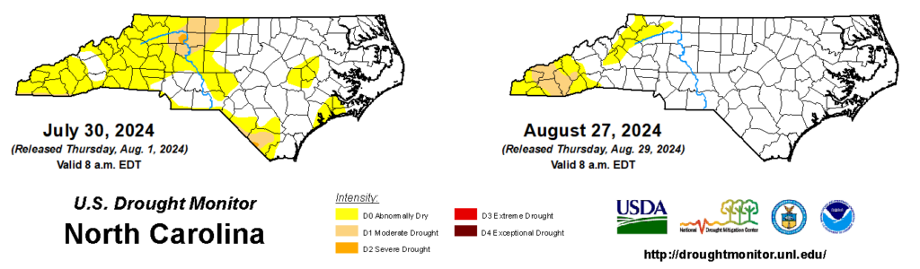
That western dryness evolved into Moderate Drought (D1) on the US Drought Monitor by the end of the month. The main impacts to this point have been to surface water levels, including low streamflows along the Pigeon River and Little Tennessee River. That prompted the towns of Canton and Clyde in Haywood County to request voluntary water conservation since their own supplies from the Pigeon River have been affected.
A Taste of Fall Before Summer Surged Back
Cool and cloudy weather early in August was offset by late-month heat, leaving our average temperatures near normal overall. NCEI notes a preliminary statewide average temperature of 76.0°F and our 59th-warmest August out of the past 130 years.
The first significant cool-down of the month came during Debby’s passage, as cloudy and rainy days kept our high temperatures in the low to mid 80s. Our temperatures tumbled again by August 20 as a cold frontal passage ushered in a cooler air mass from the northwest.
On August 21, high temperatures never made it out of the 70s across much of the state. The following morning offered the first taste of fall for the season, with lows hitting the mid-50s for the first time since the beginning of June. The northern Mountains even dipped into the 40s, with Boone hitting 47°F about a week earlier than the average first morning that cool.
But as a reminder that we were still in the summer season, Mother Nature cranked up the thermostat during the last week of the month, with highs reaching well into the 90s in most areas by August 29.
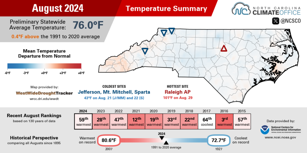
Even western sites felt the heat, including Hot Springs topping out at 96°F. It has now had 7 days so far in 2024 with highs of at least 95°F, which is the most to this point in a year since 2016.
Along with extreme temperatures reaching up to 99°F at the Charlotte airport, parts of the Charlotte metro region dealt with high ozone levels throughout the week.
Ground-level ozone formation requires pollutants such as nitrogen oxides and volatile organic compounds reacting with sunlight, and the final week of August saw plenty of hot, sunny weather, along with a stagnant air mass in which those precursor pollutants had built up from local industrial sources and wildfire smoke from as far away as central Canada.
On August 27, the Division of Air Quality’s monitor at University Meadows in northeastern Mecklenburg County had a daily ozone Air Quality Index of 156, which is in the Code Red or Unhealthy range. That’s the highest ozone AQI recorded at that location since 2016, and the highest for that monitor since June 29, 2012, at its previous location near the Cabarrus County line.

A Summer of Extremes
The end of August meant the close of climatological summer, and it’s hard to remember another summer with as many twists and turns as this one had.
June saw the early-season arrival of extreme heat, which combined with a more than two-week dry spell led to the rapid development and degradation of drought conditions across the state. The final monthly rankings from NCEI showed this as our state’s 2nd-driest June on record.
July started with more heat that sent the Raleigh-Durham Airport’s sensors to record levels. The rain then returned farther east, with monthly totals exceeding 12 inches across parts of the Coastal Plain.
And in August, Debby’s drenching put an exclamation mark on our late-summer wet pattern, while drought popped up farther west in areas removed from the storm’s influence.
The preliminary seasonal rankings don’t convey all of those abrupt changes over time, but they do tell the story of a hot summer in which extreme rainfall outweighed extreme drought. Per NCEI, this was the 18th-warmest and 42nd-wettest summer on record in North Carolina since 1895.
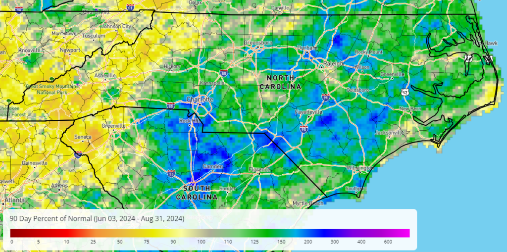
Locally, the three months from June through August ranked as the 3rd-warmest summer for Raleigh, the 4th-warmest in Asheville and Lumberton, and the 9th-warmest in Charlotte.
Through the end of August, Raleigh has recorded 64 days with high temperatures of 90°F or greater – the 6th-most on record there to this point in the year – and Fayetteville has had 63 such days, including a maximum of 101°F on July 5.
Despite the dry start to the season, it still finished as an overall wet summer for much of the state, including the 3rd-wettest on record in New Bern, the 9th-wettest in Elizabeth City, and the 15th-wettest for Greensboro.
It was drier than normal for much of the Mountains, though, with few major rain events throughout the season. Waynesville had its 3rd-driest summer on record, while it was the 2nd-driest in 33 years for Candler and the driest summer ever recorded in Franklin with only 5.03 inches – just 36% of its normal rainfall.
That local driest summer on record description is one of many extraordinary occurrences from the past season. We started with extreme heat and extreme drought in June, then picked up torrential rainfall in July and early August, and we finished the season with more heat and Code Red ozone levels in late August.
From dry to wet, drought to a tropical storm, and hot to unhealthy air quality, it was a summer of extremes for North Carolina.
- Categories:


