January’s Warm Start Flipped to a Frigid, Frozen Finish

The new year began with a memorable weather month, including an arriving chill and a wintry conclusion, which changed the landscape of our latest snow events.
Temperatures in Freefall
After warmer weather initially, a late-month chill put January’s temperatures slightly below normal overall. The National Centers for Environmental Information (NCEI) reports a preliminary statewide average temperature of 39.4°F for our 61st-coolest January out of the past 132 years, and the second consecutive cooler-than-normal January after cold and snowy weather took control early last year.
Among the colder local sites, it was the 16th-coolest January on record in Concord and Yadkinville and the 17th-coolest for Laurinburg. For two western sites with more than 100 years of observations, it notably ranked as the 21st-coolest January in Marion and the 24th-coolest in Morganton.
Last month’s temperatures were a mirror image of December, which started cold and ended warm, including new record highs on Christmas Eve. That warmth carried over into January and at times brought spring-like weather in the first two weeks of the month.
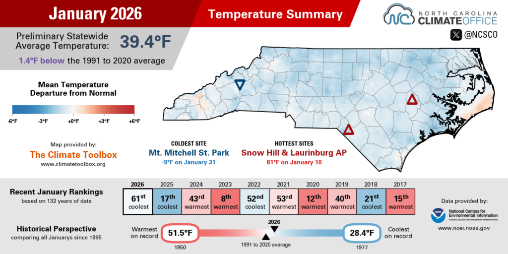
With high pressure building to our south, our temperatures topped out in the low 70s on January 7, then climbed into the mid to upper 70s on January 10. Sandhills sites in Hamlet and Laurinburg each hit the 80-degree mark for only the second time on record in January, and Snow Hill had its warmest ever January day dating back to 2010 with a high of 81°F.
A cold frontal passage on January 15 ushered in our first wave of cold weather in 2026, including overnight lows in the 10s and 20s the following morning. From there on, the chill was real as reinforcing shots of Arctic air kept arriving every few days.
During the minor ice event on January 25, temperatures in our northern counties topped out in the 20s. The highs of 20°F in Winston-Salem and 23°F in Roanoke Rapids were the coldest days in both spots since February 2015.
The following weekend during our month-ending snowstorm, temperatures were again locked in the 20s, including a high of just 26°F in Raleigh and 24°F at our ECONet station in Oxford – also the coldest day at both sites since February 2015.

Big Snow, but Little Liquid
Even the significant snow accumulations on the final day of the month couldn’t save January from its overall dry fate. Per NCEI, the preliminary statewide average precipitation of 1.95 inches ranks as our 12th-driest January since 1895.
Locally, it was the 5th-driest January on record in New Bern, the 11th-driest for Raleigh, the 14th-driest January in Charlotte and Shelby, and the 15th-driest for Elizabeth City. Both Jefferson and Fayetteville finished with their 16th-driest January on record.
In the first half of the month, the only sizable rainfall came on January 9 and 10 as a front stalled across the western part of the state. Totals reached up to 3.89 inches on Wayah Bald Mountain – the wettest day there since last April.
However, that precipitation cut off sharply across the Piedmont, and in the eastern half of the state, any precipitation proved tough to come by. In fact, Louisburg and Tarboro each received no measurable precipitation for the first 17 days of January.
An offshore low pressure system on January 18 finally brought up to an inch of rain in the Coastal Plain, plus a dusting of snow in the Triangle area. That was our first of three consecutive weekends with wintry precipitation, with each event more impactful than the one before it.

On January 24 and 25, precipitation fell as mostly sleet and freezing rain, resulting in a minor ice event that caused pockets of power outages in the southern Mountains and northern Coastal Plain.
That was followed by the grand finale: a statewide snowstorm that dropped more than a foot in spots and upwards of 20 inches in some coastal areas. Some of the more recently reported totals from that storm included 7.6 inches in Flat Springs, 10 inches in Lumberton, and 14 inches in Bayboro for the first foot of snow there since December 1989.
Unfortunately, as in January 2025, solid snow totals didn’t translate into much liquid precipitation. Even the snowiest eastern areas received barely an inch of liquid, keeping the month drier than normal overall.
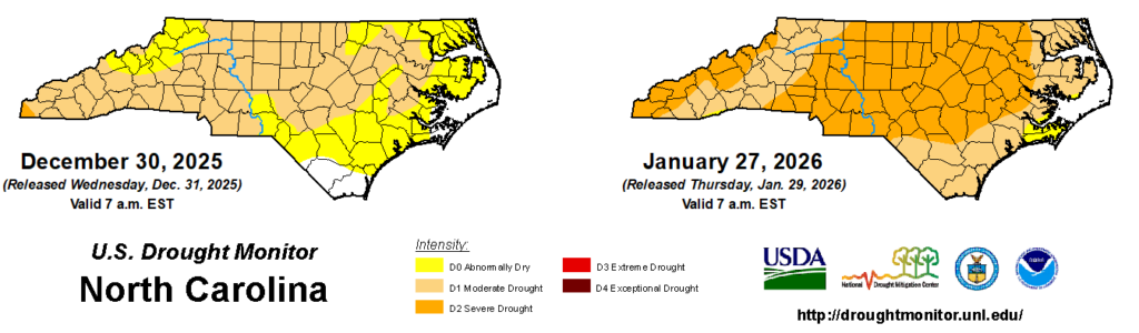
With such dry weather, we saw a net expansion of drought last month, including almost 98% of the state at some level of drought and 62% in Severe Drought (D2) on the US Drought Monitor.
The snow melt should help recharge struggling streamflow and soil moisture conditions in the coming weeks, but with precipitation deficits of more than 4 inches since November, we’re still facing widespread drought entering the final month of this climatological winter.
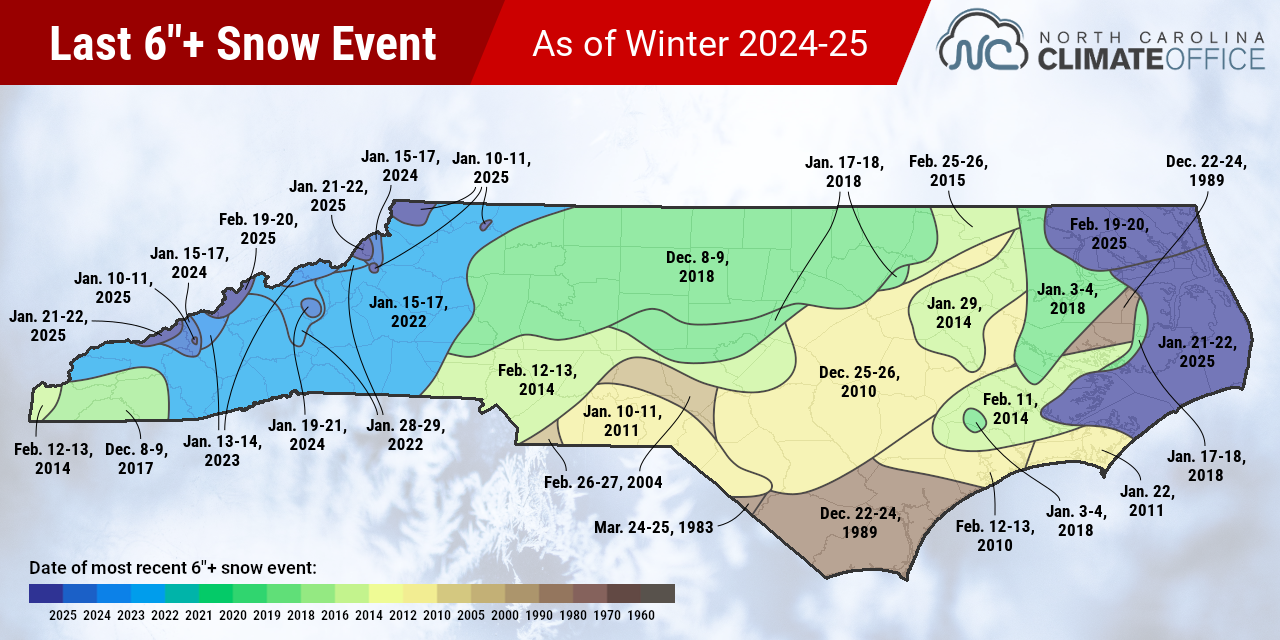
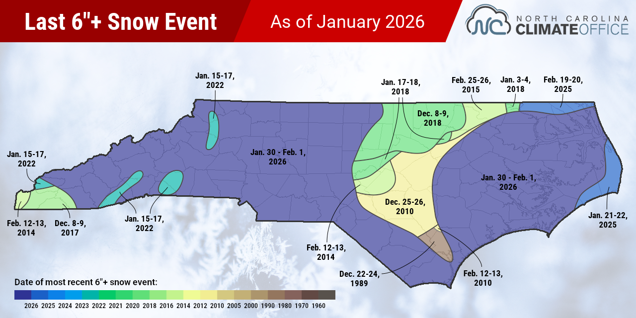
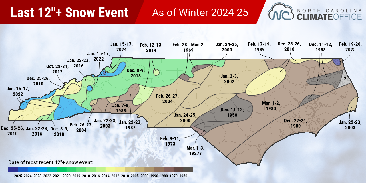
Refreshing our Recent Snow Maps
Whether it was the long-awaited return of snow in the Charlotte area or the near-blizzard conditions along the coast, our late-January snowstorm was an historic event, and the biggest snow in decades for some areas.
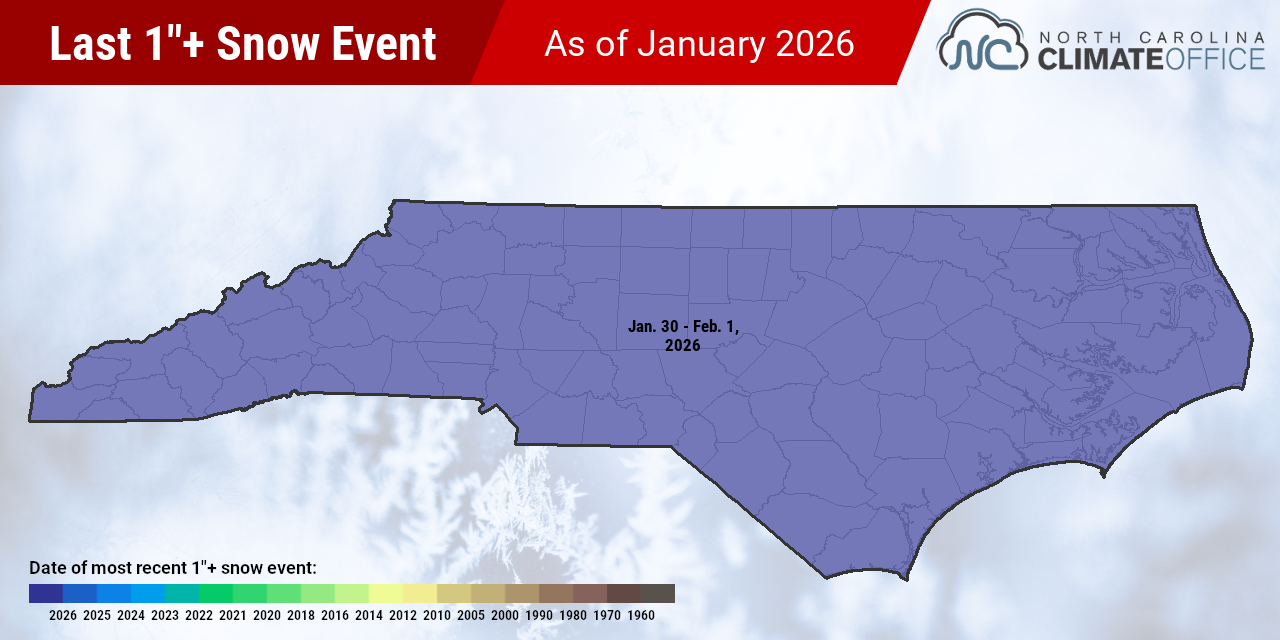
In the aftermath, we’ve updated our maps showing the latest snow events of at least 1 inch, 6 inches, and 12 inches across the state, and the results show how this latest storm left its mark. In the images below, you can compare the previous and current versions of each map by dragging the slider from left to right.
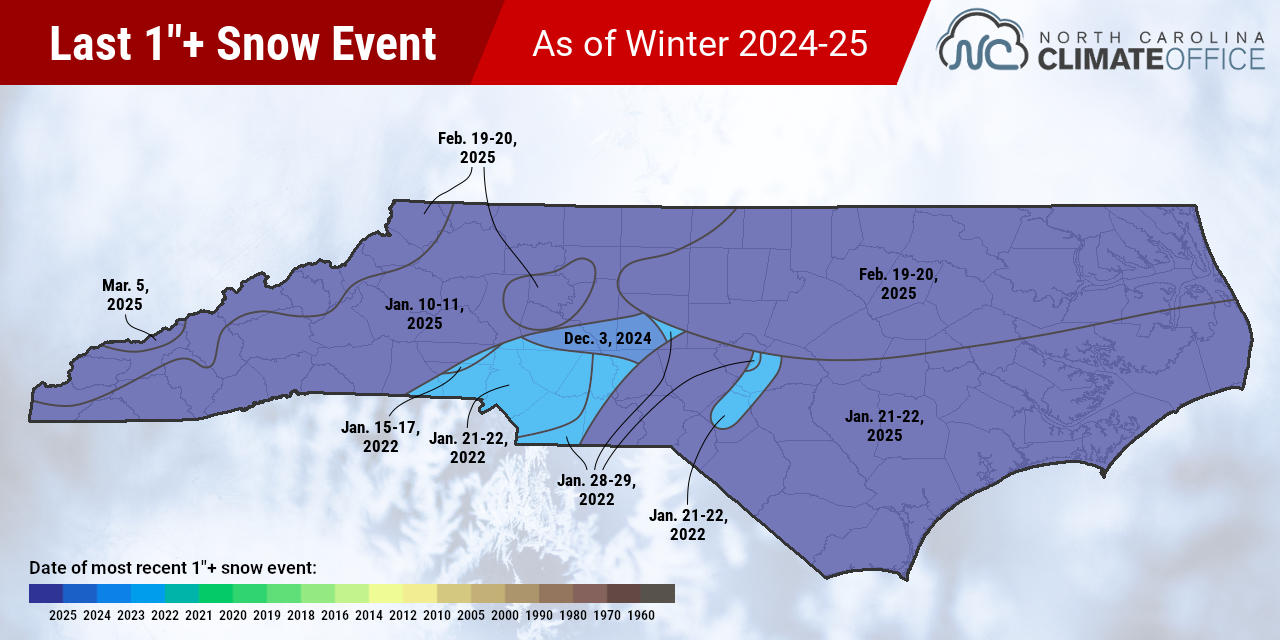
The latest one-inch event map is as simple as it can get: the entire state saw at least an inch of snow from our late January storm. For parts of the southern Piedmont, including Charlotte, it had been more than four years since their last inch of snow in January 2022.
This one-inch map has changed substantially over the past two winters. Prior to the late January 2025 storm, western Brunswick County hadn’t seen an inch of snow in more than 14 years. Now, areas such as Longwood have received a combined 16 inches in just over 12 months, including a foot from the latest event.
Most of the state also saw at least six inches in our late January event. In Charlotte, that was the first six-inch snow since February 2014, while parts of the Sandhills hadn’t seen a snow that big since January 2011, and southern coastal areas such as Whiteville and Southport last had six inches of snow in December 1989.
For most of Wake County, the most recent six-inch snow came in 2018 – either that January or December – while snow-starved suburbs like Garner last saw a six-inch snow during the Christmas 2010 storm, and totaled just 1.5 inches during our most recent snow event.
The latest 12-inch event map is still a hodgepodge of historical snowstorms, but with a slightly more recent flair, especially in our central Coastal Plain. Much of that region hadn’t seen a foot of snow since the 1980s, with parts of Beaufort County waiting since December 1958 for another snow that big.
Some of the longest gaps since the last foot of snow are now surprisingly far west. Areas such as Shelby and Spindale last saw 12 inches or more in January 1988, and much of Catawba County has been waiting for a foot since January 1987.

While the winter isn’t over yet, that one event last month has already solidified it as one of our snowiest seasons in recent memory, with enough to satisfy most snow lovers for years – at least outside of the shortchanged Triangle area.
The wait is now on for whatever comes next: another bout of wintry weather, or the arrival of spring to finally melt away our snowy remnants from January.
- Categories:


