The SCOfficial 2016-17 Winter Outlook

This is the third and final part of our 2016-17 Winter Outlook series including our expectations for this winter.
Freezing temperatures finally arrived across much of the state within the past week, which means that winter is on its way. What sort of weather can we expect in North Carolina? In this post, we’ll review some of the large-scale patterns likely to affect our weather, as well as past years with similar conditions, and finally, we’ll offer our office’s predictions for the coming season.
Atmospheric Patterns and Current Conditions
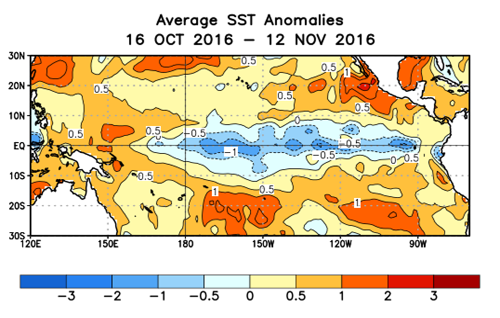
As we discussed in our last post, weak La Niña conditions emerged in the Pacific Ocean this fall, sharply contrasting with last winter’s strong El Niño. Our warm, dry weather in the past few months — Hurricane Matthew notwithstanding — may signal the arrival La Niña’s typical impacts in North Carolina. But if the La Niña weakens during the winter, those impacts could fade later in the season.
The La Niña pattern doesn’t mean the whole winter will be warm, though. October saw the 3rd-greatest snow cover out of the past 49 years in Eurasia, which hints that the polar vortex could be weakened for parts of the winter, giving cold air a chance to dive farther south.
Just to complicate matters further, there are also atmospheric indicators of a potentially strengthening polar vortex. The cyclical change of winds in the stratosphere underwent an unusual reversal earlier this year and are now fairly strong westerlies. If these winds migrate downward into the troposphere as they typically do, they would reinforce the polar vortex and the westerly winds in the polar jet stream, keeping that cold air locked up near the North Pole.
With two competing indicators of the polar vortex strength, it’s perhaps no surprise that we’ve seen a volatile polar pattern this fall. The polar vortex weakened in October, as indicated by the Arctic Oscillation dropping into negative values, but it strengthened and reconsolidated more recently. If that variability continues into the early winter, we’re likely to see some pronounced shots of colder air as well as some milder periods, similar to our weather so far in November.
Analog Years
A study of the records shows four years since 1950 with weak La Niña conditions entering the winter and a November average Arctic Oscillation value of -0.5 or less, which are similar to current conditions.
- 1950-51: A La Niña of similar strength to this year’s event resulted in a dry winter for North Carolina, and a weakened polar vortex particularly in December meant a cool start to the winter and near- to above-normal temperatures after that. Wintry precipitation was limited to two light snow events in December and February.
- 1983-84: Already-tenuous La Niña conditions in the fall weakened further as the winter went on, and the typical dry pattern was never well-established. Instead, this was a wet and slightly cooler-than-normal winter with one major snowfall and two ice storms.
- 1995-96: A weak polar vortex to start the winter brought cool weather in December and January, with near-normal temperatures in February. The winter was on the dry side overall, although January was wet with two wintry mix events. With more snow in February to boot, parts of the state received above-normal snowfall this winter.
- 2000-01: After a cool December, the weather warmed up as the winter went on. It still ranked on the cool side overall, though. It was also our 3rd-driest winter on record, which helped drought conditions expand to cover more than 70% of the state by the end of the season. The interior Coastal Plain received a major snowfall in early December, but wintry weather was limited for the rest of the season.
| Year | Dec. Ranking | Jan. Ranking | Feb. Ranking | Winter Ranking |
|---|---|---|---|---|
| 1950-51 | 11th-coolest | 42nd-warmest | 47th-warmest | 33rd-coolest |
| 1983-84 | 25th-coolest | 24th-coolest | 28th-warmest | 36th-coolest |
| 1995-96 | 19th-coolest | 34th-coolest | 57th-coolest | 19th-coolest |
| 2000-01 | 6th-coolest | 51st-coolest | 14th-warmest | 18th-coolest |
| Year | Dec. Ranking | Jan. Ranking | Feb. Ranking | Winter Ranking |
|---|---|---|---|---|
| 1950-51 | 57th-driest | 6th-driest | 28th-driest | 9th-driest |
| 1983-84 | 6th-wettest | 51st-driest | 12th-wettest | 7th-wettest |
| 1995-96 | 7th-driest | 18th-wettest | 35th-driest | 44th-driest |
| 2000-01 | 12th-driest | 13th-driest | 32nd-driest | 3rd-driest |
As the tables above show, these years share several things in common. Three of the four were drier than normal — something we’d expect from a La Niña winter. However, all four were cooler than normal, which doesn’t necessarily fit with the typical La Niña pattern.
Those overall cool conditions were driven by a weakened polar vortex, especially early in the winter. As each winter went on, the switch eventually flipped and warmer or at least near-normal temperatures arrived by February.
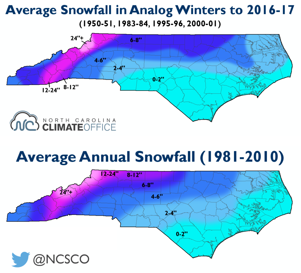
Three of these winters featured below-normal snowfall, which is also common in La Niña years. However, the northern Piedmont and Mountains received above-normal snowfall in 1995-96, which brought up the average to around normal values in those regions.
Our Outlook
The recent dry weather and La Niña conditions in place suggest more of the same to come, at least to start the winter. We have moderate to high confidence that predominantly dry weather will continue through December and likely much of January. A potentially weakening La Niña could ease some of those impacts by late winter, but for the time being, it appears we will have a tough time getting out of the dry pattern.
Drought will remain a concern this winter, as even near-normal seasonal precipitation would not lift western North Carolina completely out of the current drought. Groundwater wells in that region will take time to recover. Elsewhere, we’re likely to see drought expansion if the current dry pattern continues, even across parts of the Piedmont that saw plenty of rain from Hurricane Matthew.
Three of the analog years saw below-normal snowfall in North Carolina; however, we’re not making a snow prediction this winter. As any longtime North Carolina residents know, wintry weather can be quite fickle around here, as small differences in temperature or the timing of precipitation can make big differences in whether we receive snow, a wintry mix, or cold rain. And as the 1995-96 winter showed, all it takes is one or two big events to bring significant snow, even amid an overall dry pattern.
Each of the four analog years started with a cool December before the polar vortex eventually strengthened and warmer weather arrived by the end of winter. Because of that, we expect the best chances for below-normal temperatures will be in December and January. However, the overall confidence in our temperature forecast is low given the many variable patterns in place at the moment.
- Categories:


