Hurricanes and Tropical Cyclones
What are they?
Tropical Cyclones are large organized storms that form over warm tropical or subtropical water. Hurricanes, typhoons, tropical storms, and tropical depressions are all categorized as tropical cyclones. A tropical cyclone is said to make landfall when and where the center of the storm (also called the “eye“) comes ashore. The radius of most storms averages about 300 miles, so areas far from landfall can still feel the effects.
Tropical Cyclones in North Carolina
North Carolina is no stranger to tropical cyclones, and all parts of the state have experienced impacts. On average, our coast sees a hurricane every 5-7 years1, and we often receive remnants of storms that make landfall in other parts of the country.
Storm surge is a key threat from tropical cyclones and hurricanes along the Outer Banks and coast of North Carolina. In 2019, following devastating landfills in the Bahamas, Hurricane Dorian turned northward, eventually making landfall on Cape Hatteras on September 6. The storm brought tornadoes, rainfall of 5-10 inches, and intense storm surge to the Outer Banks, especially Cedar Island and Ocracoke Island2.
North Carolina has also experienced impacts from winds, rainfall, and flooding from hurricanes in recent years. Hurricane Florence was an historic storm for the state whose slow movement combined with heavy rains led to extensive and prolonged flooding across many parts of the state. Florence was responsible for 45 confirmed fatalities, and caused an estimated $17 billion in damages. To explore more North Carolina hurricane statistics, visit our Hurricanes Database.
Explore the topics below to learn more about tropical cyclones and hurricanes.
Ingredients for Tropical Cyclone Formation
There are several important ingredients for a tropical cyclone to form and strengthen:
- An existing disturbance. Tropical cyclones are storms, and therefore they can’t form in calm weather. Tropical cyclones typically begin as poorly organized groups of thunderstorms, termed a disturbance or tropical disturbance. In the North Atlantic Ocean, these disturbances often start as storm systems coming off the northwestern coast of Africa.
- The Coriolis Force. In the North Atlantic Ocean, most hurricanes develop between 5°N and 20°N. An unorganized group of thunderstorms needs the Coriolis force to turn them into a rotating mass of thunderstorms and ultimately a tropical cyclone. Between the equator and 5°N, the Coriolis force is too weak to cause rotation, therefore tropical cyclones typically do not form here.
- Warm sea surface temperatures.For a tropical cyclone to have enough energy to develop and continue to grow, it must pass over sea surface temperatures that are at least 80°F, and the warmer the better. One reason September marks the peak of the North Atlantic Hurricane Season is because by this point in the year the ocean has acquired all the summertime heating but has not started to cool down yet, so sea surface temperatures are at their warmest.
- High relative humidity. Tropical cyclones feed on moisture to grow and therefore need lots of moist air surrounding the storm. Sometimes dry, desert air can come off the west coast of Africa and spread over large swaths of the ocean, preventing storm development.
- Weak vertical wind shear. Tropical cyclones are well-organized storms that extend from the surface all the way to the top of the troposphere (the layer of the atmosphere where most of our weather exists) and sometimes into the next layer of the atmosphere – the stratosphere. Strong winds higher in the atmosphere (termed vertical wind shear) can literally blow tropical cyclones apart, weakening them.
Steering and Movement
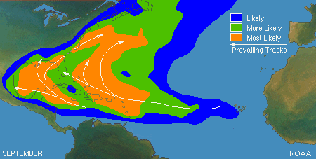
ropical cyclones, in all of their stages of development, are steered by currents in the atmosphere and the ocean. It’s for this reason that while the individual tracks of storms differ, they often follow patterns similar to those shown in Figure A above. The disturbances that come off the western coast of African are steered due west by the Trade Winds, and because of the Coriolis Force, their tracks curve northwestward at latitudes below 30°N. Above this latitude, the direction of winds shift to prevailing westerlies (“westerlies” means the winds come from the west and blow to the east) and steer storms back out to the ocean. Additionally, the clockwise-rotation of the semi-permanent high pressure system in the middle of the North Atlantic Ocean, known as the Bermuda-Azores High or simply the Bermuda High, has a role in steering storms and can have a profound effect on exactly where a tropical cyclone goes depending on its position. If it is very close to the East Coast, the clockwise flow of air around the high can steer a tropical cyclone closer to land, possibly causing a landfall. If, on the other hand, the high is farther east it will lead to tropical cyclones turning northward before they get close to land, staying out in the ocean. Combined, these factors give many (but not all) tropical cyclones a wide-arcing track that initially starts off the coast of Africa, travels west to near the Caribbean Sea or the Gulf of Mexico, then curves northeast back out to the Atlantic Ocean.
Saffir-Simpson Hurricane Wind Scale
This scale classifies hurricane strength based on wind speed. Importantly, it does not take into account any of the other impacts of hurricanes, such as rainfall, flooding, or storm surge. Any hurricane that reaches a category 3 or higher is considered a major hurricane. The table below is from the National Hurricane Center and describes each of the categories and types of damage that are possible due to hurricane winds at each level. Learn more about hurricanes from the National Hurricane Center.
| Category | Sustained Winds (mph) | Types of Damage Due to Hurricane Winds |
| Tropical Depression | < 39 | – |
| Tropical Storm | 39 – 73 | – |
| 1 | 74 – 95 | Very dangerous winds will produce some damage |
| 2 | 96 – 110 | Extremely dangerous winds will cause extensive damage |
| 3 (major) | 111 – 129 | Devastating damage will occur |
| 4 (major) | 130 – 156 | Catastrophic damage will occur |
| 5 (major) | >= 157 | Catastrophic damage will occur |
Want to learn more?
Recent NCSCO Climate Blog posts on hurricanes in NC
Information about Hurricanes from NOAA
Lesson Plans & Activities
Follow that Hurricane! Tracking and Mapping (PDF)
Hurricane Resilience Curriculum
References
- Hurricane return periods. NOAA National Hurricane Center. https://www.nhc.noaa.gov/climo/?text#returns. Retrieved March 17, 2021.
- Hurricane Dorian event summary. NOAA National Weather Service Morehead City. https://www.weather.gov/mhx/Dorian2019. Retrieved Marcy 17, 2021.