Winter Pattern Update: What Does ENSO Neutral Mean for NC?
This is the first part of our annual winter outlook series. Our outlook will be released on Thursday, November 21.
When assessing our likely wintertime weather conditions, we often start with ENSO, or the El Niño/Southern Oscillation. This pattern, which describes the cyclical warming and cooling of sea surface temperatures across the equatorial Pacific Ocean and the atmospheric circulation changes that it causes, is usually the best long-range predictor of our winter conditions.
However, ENSO doesn’t offer us many clues when it’s in a neutral state — defined by Pacific sea surface temperature anomalies within a half-degree of normal.
That’s the case entering this winter, so to better understand what an ENSO-neutral winter looks like in North Carolina, we’ve dug through the data and attempted to address some common questions and misconceptions.
What are ENSO’s impacts again, anyway?
The beating heart of ENSO is the cyclical change in sea surface temperatures across the central Pacific that tend to go from warm (El Niño) to cool (La Niña) phases every one to three years.
These changes are long-lived and widespread enough — sometimes spanning more than halfway across the world’s largest ocean — that they can induce shifts in atmospheric circulations across the globe.
Among those is the subtropical jet stream, which separates warm, tropical air from cooler, continental air. The buildup of warm water in the Pacific during an El Niño event also warms the air above the ocean surface, and an increased temperature difference between the equator and the north pole enhances the subtropical jet stream.
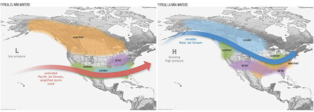
A stronger jet stream is less wobbly — think of how tough it is to bunch up a garden hose compared to a rubber band — so in El Niño winters, the subtropical jet stream tends to be anchored to our south, bringing in Gulf moisture and regular storm systems. For this reason, El Niño winters tend to be wetter than normal, as we saw last year — our 3rd-wettest winter on record.
The opposite is true in La Niña winters. Cooler water over the Pacific means cooler air in that region and a weaker subtropical jet stream, which tends to shift and bring moisture elsewhere — often over the Ohio valley, while the Southeast US remains drier. The last La Niña winter in 2017-18 was indeed on the dry side in North Carolina.
Doesn’t neutral just mean near normal?
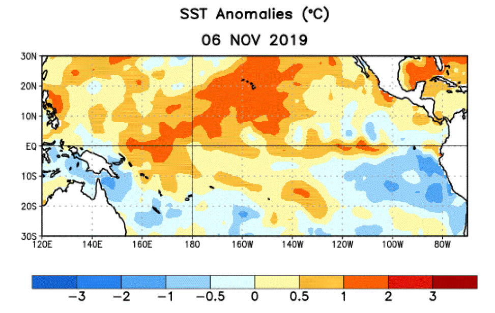
It’s true that in an ENSO-neutral winter, the sea surface temperatures across the equatorial Pacific are close to normal, just like we’re seeing now. After last winter’s El Niño event, sea surface temperature anomalies steadily declined over the summer and are now in a warm neutral state.
While there are some temperatures above the +0.5°C threshold bubbling up in spots, across a broader monitoring region, the past three months of August, September, and October have averaged just 0.1°C above normal, per the Climate Prediction Center.
With no buildup of significantly warmer or cooler water in the Pacific, ENSO-neutral events like the current one are not generally responsible for any large-scale changes in the jet stream.
However, ENSO-neutral winters don’t necessarily mean near-normal weather for us in North Carolina. Even though ENSO may not have a controlling role in our weather, other local or global patterns usually pick up the slack.
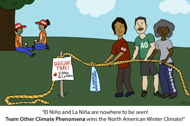
NOAA’s ENSO Blog compares it to a tug of war. If neither El Niño or La Niña have a hand on the ropes that are the jet streams, it just makes room for other patterns to step up and give them a pull.
What are these other patterns at play?
There are plenty of other phenomena that can affect our wintertime weather, but few of them offer the long-range predictability or consistent impacts on North Carolina that ENSO does. Because of that, it’s tough to tell exactly how they may shape up throughout the entire winter.
Besides ENSO, one other pattern that can affect our temperatures and moisture availability is the Madden-Julian Oscillation, or MJO. Last winter, we noted on the blog that the MJO was one pattern that helped explain our variability since the late-developing El Niño wasn’t having as much impact as expected.
To summarize, the MJO describes the movement of enhanced convection, or thunderstorm activity, around the tropics. When that convection moves over the central Pacific, the subtropical jet stream can respond like it does during El Niño events, often bringing us cooler and wetter weather as well.
Of course, these effects are short-lived since the pulses of convection constantly shift around the world, and the MJO has little predictability more than a week or so ahead of time.
For any frozen precipitation and our most potent shots of cold air, we usually rely on the polar jet stream to weaken and dive south across the eastern US. This coincides with a weakening of the polar vortex — a semi-permanent upper-level low pressure system usually centered around the north pole.
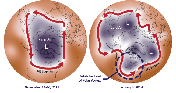
However, this oscillation also tends to, well, oscillate, over the course of days and weeks, so predicting its phase a month or two from now is essentially impossible.
Our winter weather can also be dictated by local-scale features. For example, high pressure to our north can set up a cold air damming pattern that usually leaves our weather cool and cloudy for several days.
Wind direction plays an important role in our weather as well, whether it’s a cool northerly breeze, a dry westerly wind, or a moisture-laden southerly flow.
What do ENSO-neutral winters look like in North Carolina?
The short answer: A little bit of everything.
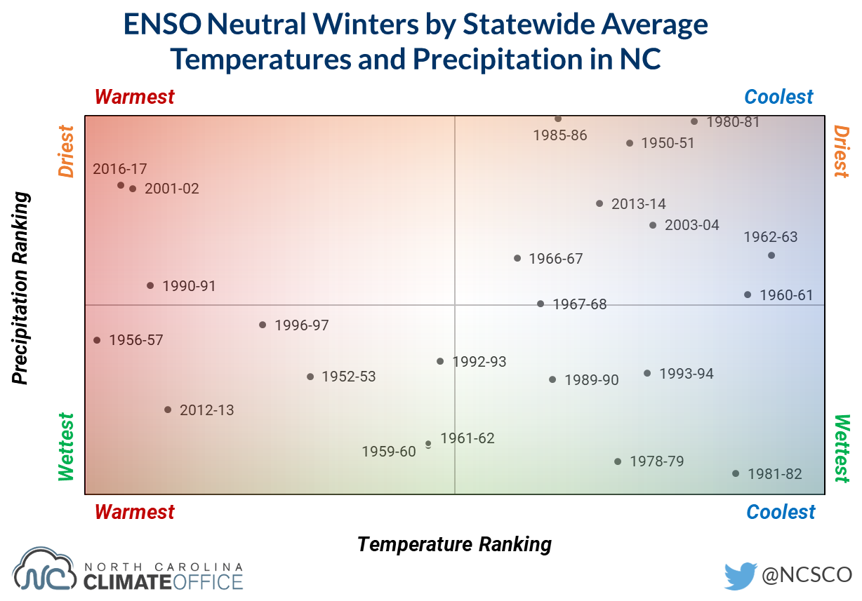
The longer answer: Since 1950, there have been 23 ENSO-neutral winters, compared to 25 El Niño and 22 La Niña winters. We plotted those 23 neutral winters based on North Carolina’s temperature and precipitation rankings for the three-month period from December through February.
Notice any major patterns in this data? Neither do we. Our neutral winters, on average, have run the gamut from warm to cool, wet to dry, and just about everywhere in between.

One thing we can say about ENSO-neutral events is that our weather rarely stays the same all winter long. Because the influence of those other patterns changes from week to week or month to month, it’s not uncommon to have very different conditions in December, January, and February.
One of our most recent neutral winters in 2013-14 was a great example of this. December was warm and wet, January was cool and dry, and February had near-normal temperatures and precipitation.
Our recap of that winter noted how variable our weather conditions were. Several weeks, we had both frozen precipitation and highs in the 70s!
That’s one reason why this year’s winter outlook is so challenging. It’s a bit like throwing a dart from 100 feet away and trying to predict which part of the board it will hit, which may vary based on your exact aim (the initial atmospheric conditions) and any small variations like air currents it encounters along its flight path (those fast-changing, tough-to-predict atmospheric patterns).
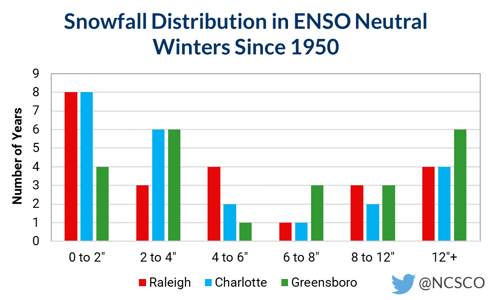
What does our snowfall look like in ENSO-neutral winters?
It has just as much variance as our temperatures and precipitation.
Consider three of the long-term monitoring stations across the Piedmont in Raleigh, Charlotte, and Greensboro. We graphed their snowfall distribution in ENSO-neutral winters (see the graph on the right), and it shows a number of years at each site with less than 2 inches of snow, but also several years with more than a foot!
Funny enough, receiving near-normal snowfall — between 4 and 8 inches, depending on the location — is actually less common in ENSO-neutral winters. That’s further proof that neutral does not always mean normal when it comes to our weather.
So which way will our weather lean this winter?
We’ll share our thoughts about this winter in our winter outlook on Thursday, but it’s safe to say that uncertainty is high given the amount of variability in ENSO-neutral winters.
The atmospheric tug-of-war is on, and we’ll have all winter to see which patterns win!
- Categories:


