Cold, Snowy Weather Dominates January
Monthly statistics for January 2014:
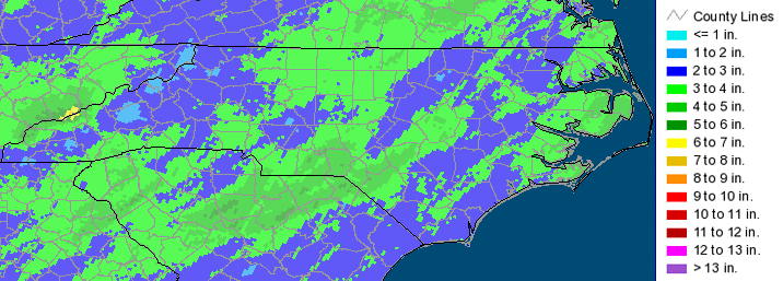
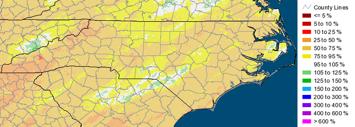
Statewide Average Precipitation: 3.38 inches (52nd driest since 1895)
Statewide Average Temperature: 33.93°F (7th coldest since 1895)
* Values generated from preliminary numbers
A Cold Start to the New Year
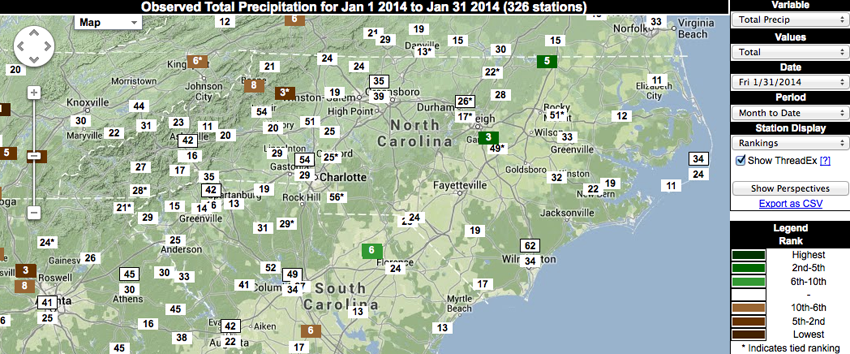
While the big story with the weather in December focused on the high precipitation amounts across the bulk of the state, January’s tale is all about temperature. On average, January tends to be the coldest month of the year for North Carolina, and last month was no different. Interspersed with a few days in the 60s and even 70s for some parts of the state, most of the month consisted of colder temperatures coming close to and even breaking records for some locations. Even more significant was the fact the one of the coldest days — January 7 — occurred with no snow on the ground, which is not typical for our state. Below are a few graphics depicting the temperature rankings for stations across the state, courtesy of the SERCC’s Climate Perspectives tool.
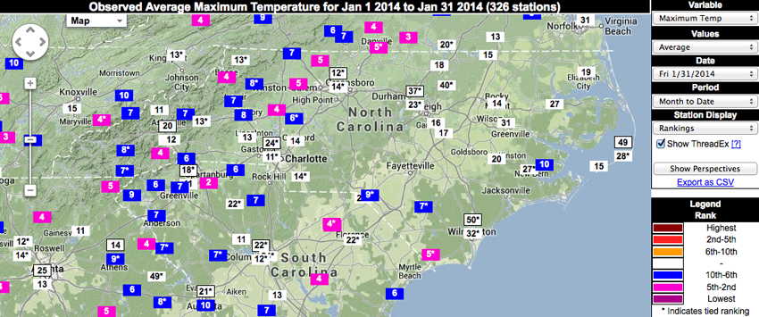
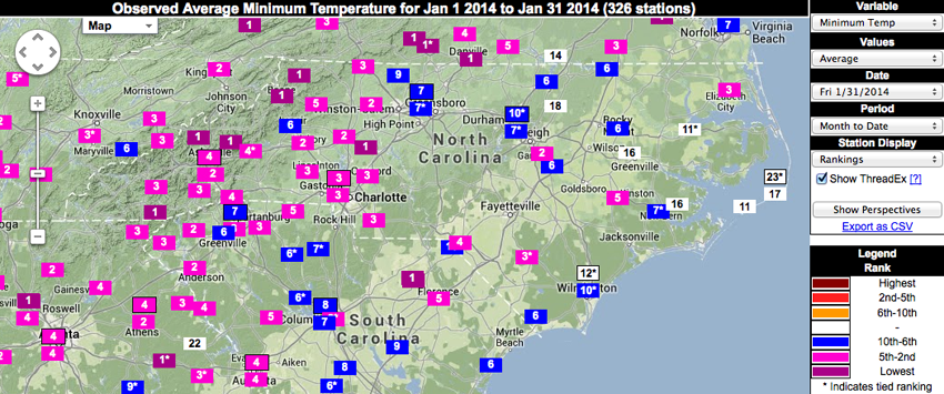
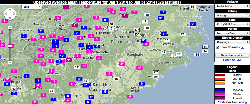
While many locations ranked last month as one of the top 10 coldest Januarys on record, the most impressive numbers are perhaps associated with those stations that had a longer period of record (50+ years) and ranked in the top 5. These locations are listed in the tables below. Note that for minimum temperature, 4 locations ranked January 2014 as the coldest January in each respective station’s history. These stations — located in Cleveland, Highlands, Jefferson and Marshall — have significantly long records of 60 years, 110 years, 78 years, and 111 years, respectively.
| Location | Maximum Temperature Ranking |
|---|---|
| Danbury | 5th coldest |
| Pisgah Forest | 4th coldest |
| Statesville | 4th coldest |
| Yadkinville | 5th coldest |
| Location | Minimum Temperature Ranking |
|---|---|
| Asheville | 4th coldest |
| Charlotte | 3rd coldest |
| Cleveland | COLDEST |
| Concord | 3rd coldest |
| Cullowhee | 3rd coldest |
| Elizabeth City | 3rd coldest |
| Fletcher | 2nd coldest |
| Hickory | 2nd coldest |
| Highlands | COLDEST |
| Jefferson | COLDEST |
| Kinston | 5th coldest |
| Laurinburg | 4th coldest |
| Lincolnton | 3rd coldest |
| Marion | Tied for 4th coldest |
| Marshall | COLDEST |
| Monroe | 3rd coldest |
| Mount Airy | 3rd coldest |
| Pisgah Forest | 3rd coldest |
| Statesville | 2nd coldest |
| Tryon | 4th coldest |
| Waterville | 3rd coldest |
| Yadkinville | 2nd coldest |
| Location | Mean Temperature Ranking |
|---|---|
| Charlotte | 4th coldest |
| Cleveland | 4th coldest |
| Cullowhee | 4th coldest |
| Hickory | 4th coldest |
| Highlands | 2nd coldest |
| Jefferson | 5th coldest |
| Laurinburg | Tied for 3rd coldest |
| Marshall | 3rd coldest |
| Monroe | 4th coldest |
| Mount Airy | 5th coldest |
| Pisgah Forest | 4th coldest |
| Smithfield | 5th coldest |
| Statesville | 4th coldest |
| Tryon | 5th coldest |
| Waterville | 3rd coldest |
| Yadkinville | 2nd coldest |
From a Wet December to a Dry January
January 2014 was a relatively dry month, with very little liquid precipitation that amounted to below-normal totals. Perhaps due at least in part to the high rainfall amounts observed in December, last month’s predominantly dry weather did not have any significant drought impacts. Currently the southeastern coast is the only area of the state experiencing Abnormally Dry conditions, as this region has not observed much precipitation in the past few months.
Let it Snow!
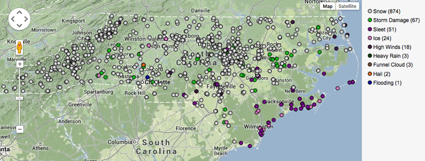
January 2014 was impacted by 3 winter storms that brought anywhere from a trace up to a foot of snow to parts of North Carolina on January 15-16, January 21-22 and January 28-29. Below is a map of Local Storm Reports provided by the National Weather Service office in Raleigh. While this map is dominated by the snow and ice reports from last month’s winter weather, you will also see reports associated with a line of severe weather (hail, high winds, storm damage, and even a funnel cloud) that moved rapidly across the state on January 11.
- Categories:


