Where does our weather come from?
Fronts
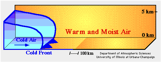
Air picks up the characteristics of the surface over which it sits. For example, an air mass over a desert becomes hot and dry; an air mass over the Gulf of Mexico becomes warm and humid; and an air mass over Antarctica becomes very cold and very dry. Air masses rarely stay in one place for very long, and as they move they can bump into other air masses. Fronts mark the boundary between two air masses. The air masses can have large temperature contrasts over a short distance on either side of the front. As a front moves past you, there is often a shift in wind direction as well as changes in temperature and humidity as the new air mass moves in. A warm front occurs when a warmer air mass is moving into a cooler air mass, while a cold front happens when a cooler air mass is moving into a warmer one. On a weather map, warm fronts are represented by lines with red semi-circles that face the direction the warm front (and the air mass behind it) is moving. Similarly, cold fronts have blue triangles, while stationary fronts are represented by interchanging the symbols for warm and cold fronts. Follow this link to see the current conditions throughout the United States! Fronts on a weather map can also be located by the change in pressure along the front, since fronts are often associated with areas of low pressure (see Mid-latitude Cyclones below).
Mid-latitude Cyclones
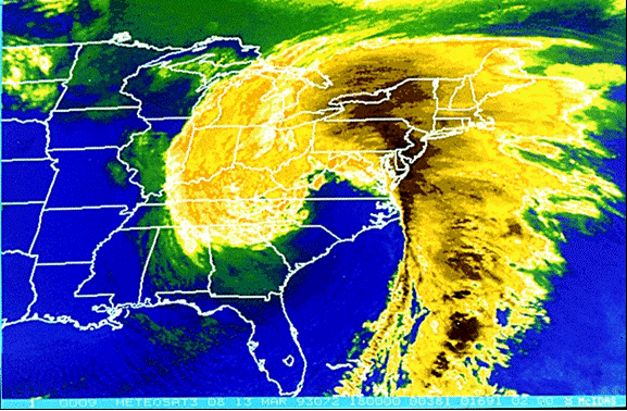
Mid-latitude cyclones, also known as extratropical cyclones, are huge weather systems that occur most often during the winter season in the United States. Their name is derived from the fact that they generally exist within 30-50 degrees latitude, or the “middle latitudes.” These weather systems pop up easily during our winter because of the large temperature difference between the equator and the North Pole. Mid-latitude cyclones can bring severe weather across the entire US with one system. Figure A is an image of a mid-latitude cyclone that occurred in 1993, which is called both the “’93 Superstorm” and the “Storm of the Century.” This cyclone formed in mid-March and lasted for 4 days, bringing blizzard conditions to the East Coast. Mid-latitude cyclones are easily identified on satellite pictures by their “comma” appearance. Want to learn more about mid-latitude cyclones? Click here to visit a page from the National Park Service!
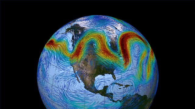
Jet Streams
Jet streams are the major means of transport for weather systems. A jet stream is an area of strong winds ranging from 120-250 mph that can be thousands of miles long, a couple of hundred miles across, and a few miles deep. Vertically within the atmosphere, jet streams usually sit at the boundary between the troposphere and the stratosphere at a level called the tropopause. This means most jet streams are about 6-9 miles off the ground.