Thunderstorms
Towering cumulonimbus clouds and the sound of rumbling thunder are common occurrences during North Carolina’s summer afternoons and evenings. During the warmer months of the year, the weather in our state is driven by more local-scale convective processes as the jet stream retreats north. The popup showers we experience during this time of year are generally small (one to a few miles across) and produce very intense, very local rainfall. During the spring and summer, we often experience thunderstorms associated with the passage of warm and cold fronts as storms developing along the frontal line and can impact all parts of the state. Thunderstorms in North Carolina bring strong winds and intense rain that can lead to localized flash flooding. Sometimes these storms also produce hail and tornadoes or damaging straight-line winds. Read on to learn more about thunderstorms!
Life Cycle of a Thunderstorm
The three main ingredients for a thunderstorm to grow and develop are instability, moisture, and a lifting mechanism (such as convection). The information below will further explain the development of thunderstorms when all of these ingredients are available.
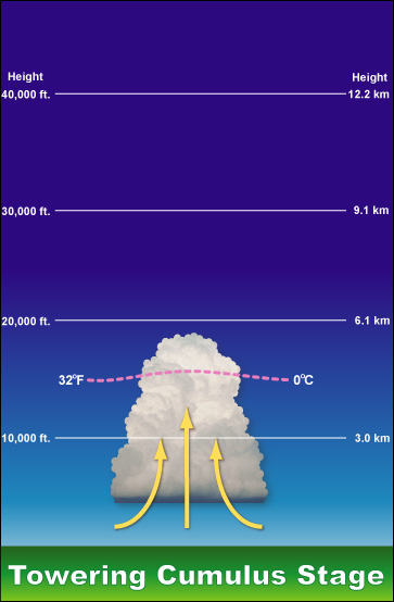
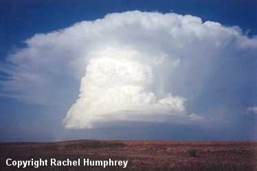
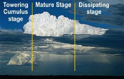
The life of a typical non-severe thunderstorm goes through three stages: Cumulus, Mature, and Dissipating (Figures A, B, & D). In the first stage (cumulus), we see the cloud that will become the thunderstorm starting to form and grow due to the rising thermal (or updraft). The rising updraft of air will begin to cool and condense as it rises, and in the case of thunderstorms, the thermal can travel tens of thousands of feet up before it finally stops! During this stage, small raindrops may begin to form and try to fall; however, the wind flow in the updraft can push the raindrops higher into the cloud rather than letting them fall out. At that level the raindrops collide and join into larger droplets due to the churning turbulence in the cloud.
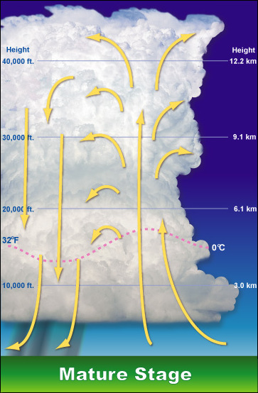
Eventually, the raindrops will become large and heavy enough to fall from the cloud to the ground. This marks the beginning of the second stage (mature). The term downdraft is used to describe the rain and the cool air that begins to descend from the thunderstorm. You can think of a downdraft as a blob of cool air in the cloud that is heading toward the earth’s surface (opposite of an updraft). Downdrafts can change the temperature rapidly in an area in a short amount of time. For example, during a hot, summer afternoon in Sattley, California, the temperature was a blazing 97 degrees at 4:00 P.M. However, after a thunderstorm passed through the area, the downdraft dropped the temperature to a cool 57 degrees by 5:00 P.M., a 40 degree temperature swing in one hour! However, most storms cool things off a more modest 10-15 degrees because of evaporative cooling.
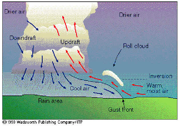
When the downdraft hits the ground, it begins to spread out in all directions. When this happens, a gust front can form. The gust front is basically a boundary that separates the rain-cooled air from the surrounding warm air shown in Figure C. Sometimes, a menacing-looking shelf cloud or roll cloud will form along the gust front. As you can imagine, the wind behind the gust front can be very strong, sometimes even reaching severe levels.
During the mature stage, the heaviest rain and (sometimes) hail fall from the storm. As long as the updraft can keep feeding the thunderstorm warm, humid air, it will continue to grow and intensify. However, the downdraft will usually end up killing off the thunderstorm as it will cut off the updraft’s supply of warm, humid air. Once this happens, the storm goes into its last stage (Figure D).
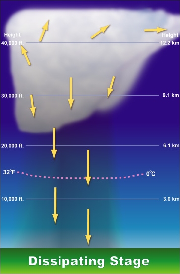
During dissipation, the updraft is very weak or non-existent, and the downdraft is the main dominant force in the thunderstorm. The thunderstorm slowly dies out and leaves only wispy clouds behind as evidence of its existence. This whole process usually goes by rather quickly and lasts about 30 minutes to an hour.
In severe thunderstorms, this cycle is extended because of differences in the inflow of warm, moist air into the thunderstorm. If the updraft is slanted, then the rain that falls out of the cloud will not cut off the inflow of the moist air that is the thunderstorm’s fuel, allowing it to continue for a much longer time period. Some severe thunderstorms have been known to last for hours and travel at speeds up to 70 miles per hour.
Types of Thunderstorms
Single Cell
Single cell thunderstorms are sometimes referred to as “airmass”, “popcorn”, or “pulse” thunderstorms, and usually do not produce severe weather. They often form in regions of warm, moist air with no strong fronts in the area. Each thunderstorm follows the life cycle of a typical thunderstorm with development, maturity, and decay occurring over a period of 30 minutes to an hour. They may contain heavy rain and can also produce occasional downbursts, small hail, and (rarely) weak tornadoes.
Multi-Cell Clusters
Multi-cell clusters are basically what the title says; a cluster of thunderstorms that form and move together. But how do multi-cell clusters form?
When a single cell thunderstorm forms, it produces a downdraft that can create a gust front of cool air near the ground. The gust front contains denser air than its surroundings, and as it spreads out, it ‘lifts’ the surrounding warm air around it. That ‘lift’ may be just enough to create another updraft which would lead to the formation of one or more additional thunderstorms. This cycle can repeat itself for hours before the cluster of thunderstorms finally dies down. Much like single cell thunderstorms, multi-cell thunderstorms are usually just heavy rain makers, but can produce hail, strong winds, and occasional tornadoes.
Multi-Cell Lines
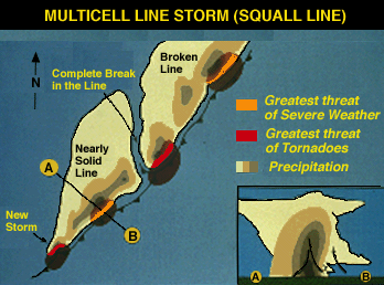
Multi-cell lines are like multi-cell clusters except that they form in a line rather than in a group together. These lines of storms are often called squall lines and they can stretch up to several hundred miles long. The gust front in squall lines is focused mostly ahead of the storms rather than spreading out in all directions. The most dangerous feature with squall lines are often the winds, as winds with these lines can sometimes exceed over 70 mph! Other threats include isolated tornadoes, hail, and flash flooding. Squall lines most often form in the warm, moist air ahead of an advancing cold front and can move through several hours before the main front passes.
Supercells
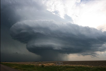
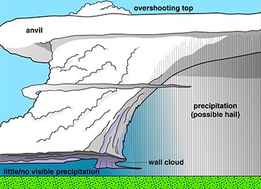
Supercells are the most dangerous kind of thunderstorms as they can produce large hail, dangerous winds, and violent tornadoes. In 2009, a supercell in Aurora, Nebraska dropped hail so large that it left holes in a roof of a house that were big enough to crawl through! Other supercells that day produced tornadoes in Kansas and Nebraska, but luckily no one was hurt. Thankfully, supercells are one of the rarest kind of thunderstorms that exist and only form under certain conditions. What makes a supercell unique from all other thunderstorms is the presence of a mesocyclone. A mesocyclone is basically an area of strong updrafts which spin as the air moves upwards. The main way mesocyclones form are from the wind shear in the atmosphere. On radar, supercells can often be seen in a typical “hook echo” pattern, which shows a rain-free area right where the strongest updraft is occurring. The large hail and/or tornadoes are most often found in the wrap-around hook near the back of the storm as it is seen on radar.