The El Niño Southern Oscillation
The El Niño Southern Oscillation, or ENSO, describes water temperatures in the eastern tropical Pacific Ocean and the linkages to weather and climate patterns around the world. ENSO tends to be the best predictor of our weather (in North Carolina) on a seasonal timescale.
Typical Annual Pattern
For most of the year in the tropics, the trade winds push the warm surface waters of the equatorial Pacific Ocean westward, allowing the upwelling of cold, deep ocean waters in the eastern Tropical Pacific. As the seasons shift, these trade winds weaken, and warm water is able to extend farther eastward — this typically happens around December. In this normal pattern (which is called the Walker Circulation), warmer water piles up in the western equatorial Pacific Ocean — in fact, the elevation of the ocean off the east coast of Australia is as much as 40 cm higher than the elevation of the ocean surface off the west coast of South America! The warm surface water imparts this characteristic to the air above it: the air becomes warmer, less dense, and rises. For this reason, in a typical year we would see more rising air, clouds, and storms over the western equatorial Pacific. In contrast, in the eastern equatorial Pacific, the cool waters lead to cooler and denser air, which sinks; clouds and precipitation are unlikely, and this is one of the reasons the Atacama desert is on the west coast of South America. This typical pattern, combined with the Earth’s rotation, leads to prevailing easterlies (the Trade Winds) in the equatorial Pacific Ocean. Sometimes this typical pattern intensifies or even completely reverses; when this happens, we experience different phases of the El Niño Southern Oscillation (ENSO) known more commonly as El Niño and La Niña. Read the sections below to learn more about each of these climate patterns and what they mean for our weather in North Carolina.
El Niño
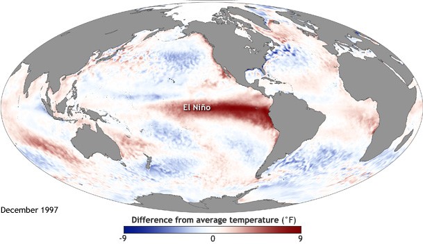
El Niño events typically occur every three to seven years and start when the trade winds blowing from the northeast, near the equator in the Northern Hemisphere, weaken. In a strong event, the winds can actually reverse and flow from the west. The trade winds weaken because the air pressure gradient between the eastern and western tropical Pacific decreases. As the winds die down, warm water from the western equatorial Pacific sloshes back towards South America, thickening the layer of warm surface water and cutting off the upwelling of nutrients from the deep ocean near Peru and Ecuador. This leads to the death of fish and the birds that feed on the nutrients, leading to economic impacts on commercial fishing and guano gathering for fertilizer from the nesting areas of the birds.
An area of thunderstorms and intense rainfall often accompanies the pool of warmest water, leading to changes in precipitation amounts along the South American coast. This causes flooding in western South America where it is usually dry and makes it excessively dry in the western Pacific where precipitation normally falls.
All of these changes in the Pacific Ocean change the global atmospheric circulation, which in turn affects the weather and climate patterns all over the globe. Since the air flows unimpeded around the earth a shift in the atmospheric patterns at one location (similar to placing a large rock in a river) can lead to shifts in the flow of air and atmospheric patterns downstream. Figure B shows some of the known variability in climate associated with the occurrence of an El Niño episode.
In addition, the pool of warm water in the eastern Pacific ocean aids in the transfer of heat from this location. This also affects weather patterns all over the world. Areas usually receiving great amounts of rainfall could potentially dry out during an El Niño event and vice versa for other areas that are usually dry. Over the central Pacific Ocean, typhoons usually increase during strong El Niño events due to the ample supply of warm water at the surface. Since El Niño usually reaches its maximum strength in winter, El Niño has the strongest impacts on the weather in December, January, and February in the Southeast, although it can continue to impact weather regionally for several months.
A warm-phase ENSO event, or El Niño, strengthens the subtropical jet stream and typically keeps it just to our south, which means a moisture-rich storm track through the Gulf of Mexico and off our coast. South-central Texas and the southeast US will be mostly cool and wet because the cold, moist air from the Pacific Ocean entering the southern states enhances clouds and rainfall and cools temperatures due to lack of direct sunlight. In turn, much of the northern United States and Canada will be warm during an El Niño event because the polar jet stream swings farther east over the northeastern United States. For much of the southeastern United States during the summer of an El Niño event, the climate is usually warmer and drier. The strong subtropical jet stream also tends to disrupt the development of hurricanes in the Atlantic Ocean and Gulf of Mexico. Because of that, fewer hurricanes are likely during an El Niño year in the tropical Atlantic.
La Niña
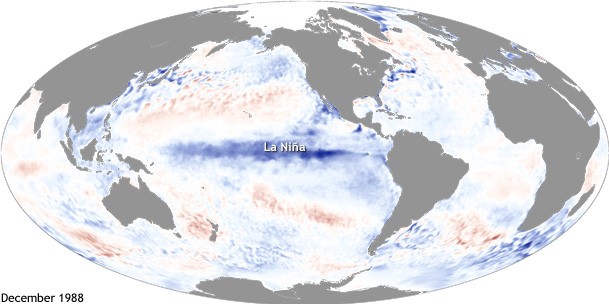
La Niña is essentially the below normal cooling of sea surface temperatures in the eastern tropical Pacific Ocean, and can be thought of as opposite to El Niño. These events often, but not always, follow El Niño events. La Niña events will vary year to year and with each event.
The eastern tropical Pacific Ocean cools during a La Niña event. This occurs because the easterly trade winds around the equator strengthen as the differences in pressure between the eastern and western tropical Pacific increase. Upwelling of colder ocean water in the eastern tropical Pacific from below the surface increases and more of this colder water moves to the west, pushed by the strong easterly trade winds. This causes the precipitation usually found over the western and central tropical Pacific to move farther to the west. This cools the average sea surface temperatures from the normal in the eastern tropical Pacific.
The polar jet stream during the winter in a La Niña event splits into two over the Pacific Ocean. This is because a persistent high pressure area resides south of Alaska and drives the upper portion of the polar jet stream to the north, while the lower portion swings around the high pressure from the south. Over Canada and the northern Great Plains, colder than normal conditions persist with the location of the upper portion of the polar jet. The southern portion of the polar jet brings warm, moist air into the northwestern United States causing much of this area to be wet. La Niña events are typically associated with warmer, dryer winters in North Carolina. During La Niña summers and falls, the subtropical jet is weakened, creating a more conducive wind environment for tropical cyclone development. For this reason, La Niña years tend to see more active North Atlantic Hurricane Seasons.
What causes the different ENSO phases?
The Southern Oscillation refers to a seesaw effect of surface atmospheric pressure between the eastern and western equatorial Pacific Ocean in which higher-than-normal pressure in one of these two regions is coincident with lower-than-normal pressure in the other. These pressure changes result from several years of sea surface temperature variations in the equatorial pacific — establishing the link between El Niño/La Niña and the Southern Oscillation — hence the term El Nino Southern Oscillation, or ENSO.
Click here for more information about the El Niño Southern Oscillation (ENSO).
Image from NASA