A Divided December Started Cold, Then Heated Up

December delivered mixed temperatures throughout the month, along with more dry weather and drought in central and western North Carolina. It also left us with a few more records to tally from 2025.
From Wintry to Warm in One Month
Balanced between a chilly start and a warmer finish, our December temperatures were near-normal overall in North Carolina. The National Centers for Environmental Information (NCEI) reports a preliminary statewide average temperature of 41.8°F and our 64th-coolest December out of the past 131 years.
Monthly average temperatures were generally closer to normal in the west and cooler in the east. Hickory matched its normal temperature in tying for its 35th-warmest December in the past 75 years, and Charlotte likewise was near-normal with a tie for its 51st-warmest December since 1878.
Other major Piedmont sites were 2 degrees cooler than normal. That included Greensboro, which tied for its 61st-coolest December; Raleigh in its 53rd-coolest December; and Fayetteville in a tie for its 37th-coolest December on record.
Among coastal stations, Wilmington tied for its 38th-coolest December, Hatteras had its 31st-coolest December, and Elizabeth City tied for its 17th-coolest December dating back to 1934. This was also its coldest December since 2010.
Early on, a series of cold fronts and Arctic air masses kept cold air in place, including 12 consecutive nights with below-freezing temperatures in Raleigh – the longest such streak there in December since 2005.
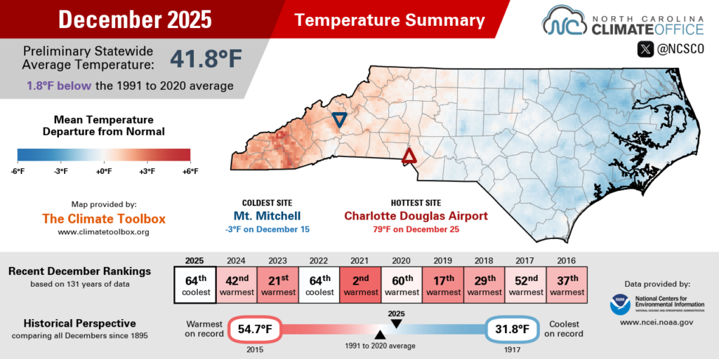
Our coldest day on December 15 saw low temperatures dip into the single digits at higher elevations, the 10s elsewhere, and even down to 23°F at Hatteras – the coldest morning there and in many areas since December 24, 2022.
Following that frigid Monday, temperatures quickly rebounded with 60s across eastern North Carolina by December 17 and even in the Mountains on December 18.
The next week was even warmer as high pressure to our south pushed temperatures into the 70s. Charlotte shattered its record highs on both Christmas Eve, reaching 77°F, and Christmas Day, at 79°F — the warmest December day there since 2007. Greensboro also set a new record on December 25, with a high of 75°F.
Fifteen years after the last White Christmas for much of North Carolina, this holiday was decidedly less wintry as part of a late-month temperature turnaround. Those extremes are evident in the final stats: even Wilmington had the same number of nights below freezing (13) as it did days hitting 60°F or warmer. From cold to warm, there was little in-between in December.

Another Dry Month in Most Areas
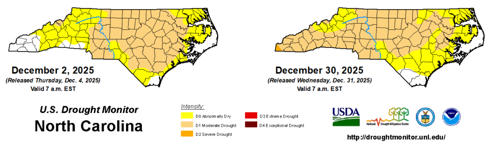
Our dry fall weather continued into the start of winter, with below-normal precipitation across the Mountains and Piedmont. NCEI notes a preliminary statewide average precipitation of 2.44 inches, which ranks as the 25th-driest December in North Carolina since 1895.
As in November, much of the state saw less than 2 inches of precipitation in December, with totals generally increasing from west to east. The driest sites included Marshall, which had only 0.83 inches in its 6th-driest December on record, and Asheville with just 1.18 inches in its 14th-driest December.
Charlotte totaled 1.82 inches in its 20th-driest December, Greensboro had 1.80 inches to tie for its 21st-driest December, and Raleigh finished the month with exactly 2.00 inches and its 27th-driest December on record.
Coastal sites fared better thanks to multiple significant rain events. An offshore low pressure system on December 2 brought an inch or two of rain across the Coastal Plain, including up to 2.37 inches at our ECONet station in Whiteville – the first day with more than an inch of rain there since October 12.

A similar system on December 5 and 6 dropped more than an inch of rain along our southern coastline, and a passing cold front on December 18 and 19 brought more widespread totals of about an inch statewide.
Some coastal areas even picked up a bit of snow on December 14 as cold air moving over the warm water of the Albemarle Sound generated a narrow band of quick-hitting but accumulating “sound-effect” snow between Plymouth and Lake Mattamuskeet.
That precipitation in all forms added up to 5.44 inches in Hatteras for its 37th-wettest December on record, while Ocracoke had 4.99 inches in its 12th-wettest December out of 40 years with observations. New Bern was a quarter-inch above normal with 3.88 inches and its 29th-wettest December since 1948.
The heavier rainfall totals along the coastline helped soil moisture levels bounce back to above normal and drought conditions to ease in parts of southeastern North Carolina. However, drier weather farther west led to the expansion of Moderate Drought into the Mountains as groundwater levels declined throughout the month of December.
While drought has shifted from east to west, the bottom line is that drought remains widespread, affecting almost 60% of the state at the end of 2025.
Record Roundup from 2025
Christmas wasn’t the only record-breaking day this year. From temperatures to extreme precipitation impacts, 2025 featured a number of local records all across the state.
Warm extremes far outnumbered cold ones, including five daily record high temperatures broken or tied in Raleigh. Those ranged from an unseasonable 80-degree day on February 4 to a sizzling 100°F on back-to-back days in late June.
July was notable for its warm nights, and based on the average minimum temperature, it was the warmest month on record in North Carolina. Raleigh tied its all-time record warm low temperature of 80°F on July 18 – one of 22 daily record warm nights in the capital city in 2025.
We followed July with a much cooler August, and Greensboro tied its record cool high temperatures on three days in a row that month. It reached only 69°F on August 5 and 6, and 75°F on August 7.

The summer also featured a soaking from Tropical Storm Chantal that broke several records across the central Piedmont. Burlington (5.75 inches), Chapel Hill (7.65 inches), and Yanceyville (8.68 inches) each set new single-day rainfall records, and gauges on the Haw and Eno rivers reached new record crests.
We even saw several precipitation records of a frozen variety last year. The mid-January snow event finally ended snow-free streaks that had lasted more than 1,000 days across the Piedmont, including record-long streaks of 1,084 days in Marion and Shelby, and 1,076 days in Charlotte.
On February 19 and 20, Elizabeth City picked up 8 inches of snow, which was its third-greatest February snow on record and the most in that month since 1980. An unusually snowy year in northeastern North Carolina resumed in November, with the earliest measurable snow on record in Edenton on November 11.
Despite those precipitation events, drought was a major storyline throughout the year, and the source of several other records. In March streamflows on the North Fork Swannanoa River in Buncombe County and Indian Creek in Lincoln County reached new monthly record low levels. And in both November and December, the Smith River at Eden bottomed out at new monthly record low streamflows.

We’ll have plenty more to share about 2025 in our upcoming Year in Review webinar, including statewide and local rankings, a review of the significant weather events, global and historical perspectives, and stories to watch in 2026.
Registration is free but required in advance for the webinar, which will take place on Tuesday, January 20 at 11 am Eastern. Following the presentation, we’ll open the floor for a Q&A.
If you’re unable to attend live, the webinar will be recorded, and a summary blog post will be published immediately afterwards. We look forward to reviewing the past year and previewing 2026 in this annual webinar tradition.
- Categories:


