
This post is part of our year-long series about North Carolina’s weather extremes.
One of our state’s most notable floods wreaked havoc on western North Carolina residents in July 1916, breaking multiple records and leaving death and destruction in its wake.
The Preceding Weather
In late June 1916, a tropical depression formed in the western Caribbean just east of Nicaragua. The storm reached hurricane status as it entered the Gulf of Mexico, making landfall in Mobile, AL at Category 3 strength on July 5. As is the case with many tropical cyclones, intensity drastically decreased soon after landfall. However, the system remained intact for several days, taking a very slow and winding trek over the Southeast. Eventually coming to linger over the Southern Appalachian mountains, the storm brought several inches of rain to western North Carolina for over a week — most notably on July 8-10 — saturating soils and filling stream banks to the brim.
The Main Event
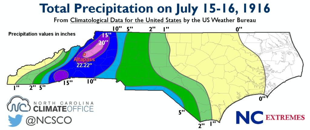
As rains from the Gulf Coast storm began tapering off, another storm brewing in the Atlantic made its journey toward the eastern U.S. This storm made landfall on July 14, 1916 near Charleston, SC as a Category 2 hurricane, and traipsed across the state on a northwestern track. While many tropical cyclones often take a more northeastern course once they reach higher latitudes, a large area of high pressure over the New England states prevented such a track, forcing the storm in the direction of the Southern Appalachians. In the morning hours of Saturday, July 15, heavy rain from the storm began to fall across North Carolina, stretching from the eastern foothills to the Blue Ridge Mountains. By Sunday, precipitation totals in western NC ranged from 5 inches to over 20 inches.
The storm’s northwesterly track, along with the orientation of winds, lined up almost exactly perpendicular to the peaks in the northern mountains, putting this area in a prime location for upsloping. As a result, a weather station in Altapass measured 22.22 inches of rain from 2:00pm July 15 to 2:00pm July 16, shattering the U.S. record for the most rainfall within 24 hours at that time. While this U.S. record has since been broken and currently stands with a station in Texas, Altapass still holds the statewide record for most rainfall observed in a 24-hour period.
But the story still wasn’t over. With the ground thoroughly soaked, and lakes and streams already at capacity as a result of the tremendous amount of rain observed in the weeks prior, the water had nowhere to go — and soon unleashed its fury across the region.
The Impact
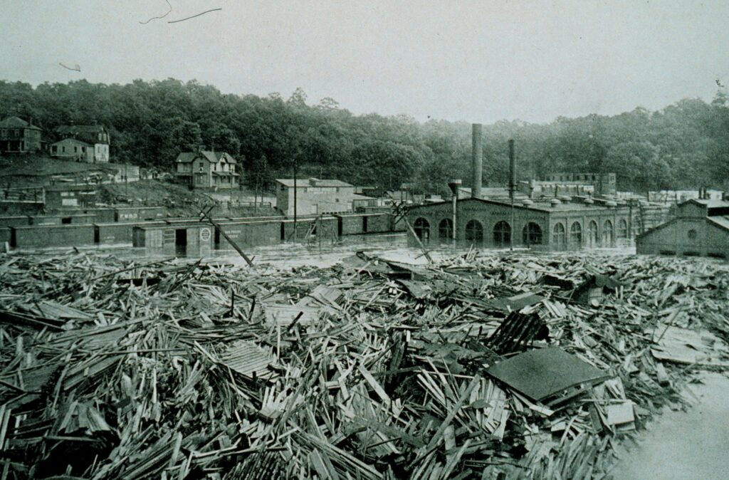
The French Broad River quickly became inundated as the raging waters flowed into the heart of Asheville at high speeds and volumes never-before experienced. Upon colliding with the Swannanoa, floodwaters rapidly overtook Biltmore Village, resulting in one of the worst incidents of flooding that area has ever seen. A streamflow gauge along the French Broad reached a stage of 18.6 feet at 9:00am on July 16. By 10:00am, the bridge to which the gauge was attached was completely destroyed, and water continued to rise to an estimated 21 feet — 10.4 feet above the record flood at that time.
Meanwhile the Catawba River was experiencing its own turmoil. A streamflow gauge in Mount Holly reached an estimated stage of 45.5 feet (almost double the record previously set in 1901) — an estimate, mind you, due to the fact that this gauge, too, had been completed washed away by the torrential waters.

Landslides were observed left and right as the floodwaters engulfed the region. Homes and business were swept away; crops were completely wiped out; numerous bridges and mills were demolished; and several railroad lines were severely damaged. In one particular case, a railroad trestle over the Catawba River was completely washed away. The event claimed the lives of more than 80 people overall, including workers with the Southern Railway Company as they attempted cleanup in the days to follow.
Floodwaters took roughly 2 days to completely recede. Estimated damage costs over the region exceeded $22 million, which equates to roughly $480 million by today’s standards. Perhaps the greatest single loss of property was that of the Southern Railway Company, which suffered damages around $1.2 million as a result of broken railways, shattered roundhouses, and flooded passenger stations. Of course, this figure doesn’t take into account the decreased railroad traffic the company endured, nor the cost they accrued in having to detour trains.
Since The Storm
While an exact timeline is unknown, the greater mountain region eventually recovered. Homes that had been destroyed were rebuilt, and industries devastated by the destruction eventually sprang back to life.
Many people remember a similar flood that rivals the devastation seen in North Carolina back in 1916 — one that occurred over the same area just over a decade ago. In 2004, western NC was hit repeatedly as two hurricanes — Frances and Ivan — trekked over the region with only 9 days separating them. Flood water levels from both the 1916 flood and that of 2004 were nearly identical, as were precipitation totals. The highest rainfall amount reported with Hurricane Frances was 18.1 inches in Linville Falls, while Cruso, NC received the most precipitation from Hurricane Ivan just days later with a 17-inch total.
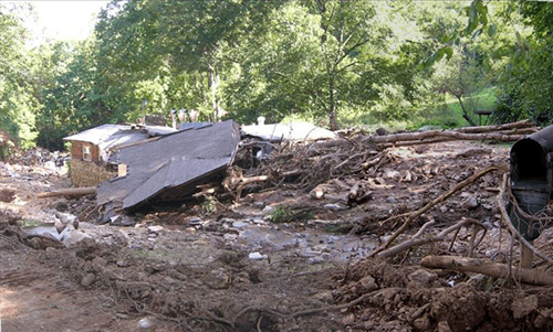
Although the destruction from the 2004 flood wasn’t as great as the 1916 event, it did take a toll on western North Carolina. Eleven deaths were reported due to the flooding from Frances and Ivan, and damages were estimated at nearly $200 million.
And while other events have threatened the Altapass record from July 1916 — such as the 18+ inches observed in Southport as Hurricane Floyd passed through in September 1999 — the torrential rainfall it received in just 24 hours remains unchallenged in North Carolina’s record books.
Sources:
- Hell and High Water by OurState
- Hurricanes Frances, Ivan: Impact Lingers 10 Years Later from the Asheville Citizen-Times